IMAGES TAKEN NEAR TO
High Meadows, BROMSGROVE, B60 3QR
Introduction
This page details the photographs taken nearby to High Meadows, B60 3QR by members of the Geograph project.
The Geograph project started in 2005 with the aim of publishing, organising and preserving representative images for every square kilometre of Great Britain, Ireland and the Isle of Man.

There are currently over 7.5m images from over14,400 individuals and you can help contribute to the project by visiting https://www.geograph.org.uk
Image Map
Images are licensed for reuse under creativecommons.org/licenses/by-sa/2.0
Notes
- Clicking on the map will re-center to the selected point.
- The higher the marker number, the further away the image location is from the centre of the postcode.
Image Listing (7 Images Found)
Images are licensed for reuse under creativecommons.org/licenses/by-sa/2.0
Image
Details
Distance
2
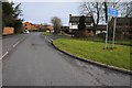
Welcome to Bromsgrove
Worcester Road, B4091 approaching Bromsgrove
Image: © Roy Hughes
Taken: 2 Mar 2009
0.05 miles
3
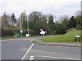
Direction Sign ? Signpost in Rock Hill, Bromsgrove
Located in Rock Hill, Bromsgrove, on the east side of the T junction of the B4091 and Grafton Lane. 1 arm and no finial.
Milestone Society National ID: WO_SO9469
Image: © Roadside Relics
Taken: 13 Jul 2021
0.07 miles
4
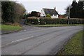
Dark Lane
The junction of Dark Lane with Hanbury Road in Stoke Heath.
Image: © Philip Halling
Taken: 20 Feb 2015
0.16 miles
5
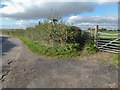
Grafton Lane footpath
The point where the footpath leaves Grafton Lane and heads off across the fields.
Image: © Mike Dodman
Taken: 18 Oct 2016
0.20 miles
6
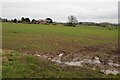
Bowling Green Farm
Bowling Green Farm viewed from Grafton Lane
Image: © Philip Halling
Taken: 20 Feb 2015
0.23 miles
7
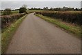
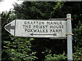
Grafton Lane
Grafton Lane is a no through road which provides access to Grafton Manor and Foxwalks Farm beyond the motorway.
Image: © Philip Halling
Taken: 20 Feb 2015
0.25 miles