IMAGES TAKEN NEAR TO
Waggoners Close, BROMSGROVE, B60 3QN
Introduction
This page details the photographs taken nearby to Waggoners Close, B60 3QN by members of the Geograph project.
The Geograph project started in 2005 with the aim of publishing, organising and preserving representative images for every square kilometre of Great Britain, Ireland and the Isle of Man.

There are currently over 7.5m images from over14,400 individuals and you can help contribute to the project by visiting https://www.geograph.org.uk
Image Map
Images are licensed for reuse under creativecommons.org/licenses/by-sa/2.0
Notes
- Clicking on the map will re-center to the selected point.
- The higher the marker number, the further away the image location is from the centre of the postcode.
Image Listing (14 Images Found)
Images are licensed for reuse under creativecommons.org/licenses/by-sa/2.0
Image
Details
Distance
1
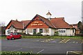
The Golden Lion (1), Austin Road, Charford, Bromsgrove
A modern community pub in a large estate, it is owned by Marston's Brewery, whose pub department have just advertised the pub as being available to let. They are hoping that the food and entertainment sides can be further developed.
Image
Image
Image: © P L Chadwick
Taken: 21 Jan 2012
0.11 miles
2
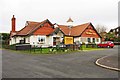
The Golden Lion (3), Austin Road, Charford, Bromsgrove
Modern estate pub owned by Marston's. It mainly serves the local community, as it is not on a major road.
Image
Image
Image: © P L Chadwick
Taken: 21 Jan 2012
0.11 miles
3
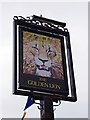
The Golden Lion (2) - sign, Austin Road, Charford, Bromsgrove
The Golden Lion is an heraldic name but an alternative explanation of its origins as a pub name is that it originated with King Henry I, who reigned from 1100 until his death in 1135. Known as the Lion of Justice, Henry started a royal menagerie at Woodstock in Oxfordshire, which included lions - reputedly the first to be seen in England. The sign is quite common although not as popular as the Red Lion.
The sign on this pub is on a post at the edge of the front car park. It is rather faded and as neither the sign nor the pub itself currently carry the Marston's brand name, it seems possible that this is a recent addition to the Marston's chain.
Image
Image
Image: © P L Chadwick
Taken: 21 Jan 2012
0.12 miles
4
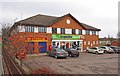
The Co-operative Food, 55 Gilbert Road, Charford, Bromsgrove
A small supermarket serving the Charford estate. It is normally open to 10pm every night.
Image: © P L Chadwick
Taken: 21 Jan 2012
0.15 miles
5
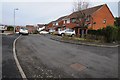
Housing estate, Stoke Heath
1980s housing estate at Stoke Heath.
Image: © Philip Halling
Taken: 20 Feb 2015
0.18 miles
6
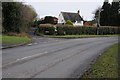
Dark Lane
The junction of Dark Lane with Hanbury Road in Stoke Heath.
Image: © Philip Halling
Taken: 20 Feb 2015
0.18 miles
7
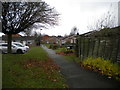
Wintour Walk, Charford
Off Gilbert Road.
Image: © Richard Vince
Taken: 1 Dec 2018
0.22 miles
8
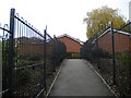
Footpath off Farmers Road, Charford
Leading eventually to Gilbert Road.
Image: © Richard Vince
Taken: 1 Dec 2018
0.23 miles
9
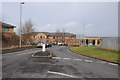
Business park at Bromsgrove
Business park on the southern fringes of Bromsgrove.
Image: © Philip Halling
Taken: 20 Feb 2015
0.24 miles
