IMAGES TAKEN NEAR TO
Housman Park, BROMSGROVE, B60 1AZ
Introduction
This page details the photographs taken nearby to Housman Park, B60 1AZ by members of the Geograph project.
The Geograph project started in 2005 with the aim of publishing, organising and preserving representative images for every square kilometre of Great Britain, Ireland and the Isle of Man.

There are currently over 7.5m images from over14,400 individuals and you can help contribute to the project by visiting https://www.geograph.org.uk
Image Map (Loading...)


Getting Data...Please wait
Leaflet Map data © OpenStreetMap
Images are licensed for reuse under creativecommons.org/licenses/by-sa/2.0
Notes
- Clicking on the map will re-center to the selected point.
- The higher the marker number, the further away the image location is from the centre of the postcode.
Image Listing (167 Images Found)
Images are licensed for reuse under creativecommons.org/licenses/by-sa/2.0
Image
Details
Distance
1

The Spadesbourne,at Housman Park, in flood following Storm Babet
Image: © Roy Hughes
Taken: 20 Oct 2023
0.04 miles
2

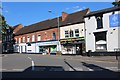
Bromsgrove The Strand
The Strand is due to be part of the Bromsgrove improvement plan.
Image: © Roy Hughes
Taken: 9 Feb 2012
0.04 miles
4
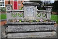
Former drinking trough
Former drinking trough, new a flowerbed on the junction of The Strand and Stourbridge Road. The inscribed plaque reads: 'In Memory of Benjamin Hadley Sanders 50 years clerk to the Bromsgrove local board. Presented by his daughters 1910'.
Image: © Philip Halling
Taken: 26 Apr 2018
0.05 miles
5
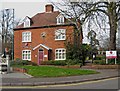
Strand House, 70 The Strand
This is the front of Strand House, but it stretches back a long way. Today it is used as offices by Thomas Horton LLP, a firm of solicitors. It was built around 1701 and in 1723 was converted and enlarged as the parish workhouse. Later it was used as a tannery. There is an attractive clock above the entrance.
Image: © P L Chadwick
Taken: 10 Apr 2010
0.06 miles
6
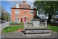
Red-brick Georgian house
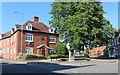
Eighteenth century Georgian house between The Strand and Stourbridge Road in Bromsgrove. The flowerbed in the foreground appears to be a drinking trough, a memorial to Benjamin Hadley-Sanders dated 1910. The clock on the building in the background is showing the wrong time, it's around midday. The building is Grade II listed, see: https://historicengland.org.uk/listing/the-list/list-entry/1100366
Image: © Philip Halling
Taken: 26 Apr 2018
0.06 miles
8

Bromsgrove Poppy Wall Outside the Methodist Church Hall
Image: © Roy Hughes
Taken: 10 Nov 2018
0.06 miles
9
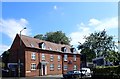
Solicitors' Offices, The Strand, Bromsgrove
Image: © Eirian Evans
Taken: 23 Aug 2019
0.07 miles
10

Bromsgrove High Street William Hill, Sweetz & Argos
Image: © Roy Hughes
Taken: 27 Feb 2012
0.07 miles