IMAGES TAKEN NEAR TO
Stratford Road, BROMSGROVE, B60 1AS
Introduction
This page details the photographs taken nearby to Stratford Road, B60 1AS by members of the Geograph project.
The Geograph project started in 2005 with the aim of publishing, organising and preserving representative images for every square kilometre of Great Britain, Ireland and the Isle of Man.

There are currently over 7.5m images from over14,400 individuals and you can help contribute to the project by visiting https://www.geograph.org.uk
Image Map
Images are licensed for reuse under creativecommons.org/licenses/by-sa/2.0
Notes
- Clicking on the map will re-center to the selected point.
- The higher the marker number, the further away the image location is from the centre of the postcode.
Image Listing (157 Images Found)
Images are licensed for reuse under creativecommons.org/licenses/by-sa/2.0
Image
Details
Distance
1
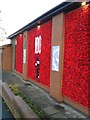
Bromsgrove Poppy Wall Outside the Methodist Church Hall
Image: © Roy Hughes
Taken: 10 Nov 2018
0.07 miles
3
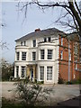
Rivendell / Wendron House
See Shared description
Image: © peter Dodman
Taken: 24 Apr 2010
0.09 miles
4
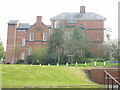
Rivendell / Wendron House
See shared description
Image: © peter Dodman
Taken: 24 Apr 2010
0.10 miles
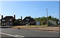
5
Bromsgrove Fire Station
Situated in Windsor Street.
Image: © David Stowell
Taken: 30 Apr 2006
0.13 miles
7

Bromsgrove High Street William Hill, Sweetz & Argos
Image: © Roy Hughes
Taken: 27 Feb 2012
0.14 miles
8
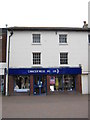
Cancer Research UK Shop - Bromsgrove
Letters missing from shop sign - As soon as they are replaced they get stolen again.
Image: © Roy Hughes
Taken: 5 Jun 2011
0.14 miles
9
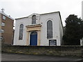
United reformed Church, Bromsgrove
Image: © Richard Rogerson
Taken: 16 Feb 2013
0.14 miles
10

The Stripped Kitchen & Shoezone High Street Bromsgrove
Image: © Roy Hughes
Taken: 30 Oct 2023
0.14 miles