1
Two-way segregated cycle lane by A38, Edgbaston
Image: © David Smith
Taken: 23 Oct 2019
0.05 miles
2
165 - 177, Bristol Road, Edgbaston
Well, technically, this photo is of 167 - 175 Bristol Road; the lens wasn't quite wide enough to capture the whole terrace in one go. They were built around 1830 as "fourth rate common passage artisans dwellings", and are pretty much unaltered in character externally but presumably somewhat modified internally. The whole row attracted a Grade II listing https://britishlistedbuildings.co.uk/101075723-165-177-bristol-road-b5-edgbaston-ward#.Xfamvej7Tcs & https://historicengland.org.uk/listing/the-list/list-entry/1075723 in 1982.
Image: © Richard Law
Taken: 17 Oct 2019
0.06 miles
3
Sir Harry's Road, Edgbaston
Sir Harry's Road approaching the point where it crosses Bristol Road, although all vehicles are obliged to turn left. The floodlight ahead belongs to the cricket ground.
Image: © Stephen McKay
Taken: 9 Jan 2016
0.06 miles
4
179, Bristol Road, Edgbaston
Immediately adjacent to the Bristol Road frontage of
Image on its left, no 179 was built around the mid 1820s as a small house, somewhat extended in the meantime. It attracted a Grade II listing https://britishlistedbuildings.co.uk/101220145-179-bristol-road-b5-edgbaston-ward#.XfaptOj7Tct & https://historicengland.org.uk/listing/the-list/list-entry/1220145 in 1982.
Image: © Richard Law
Taken: 17 Oct 2019
0.07 miles
5
181, Bristol Road, Edgbaston
This fine house, which fronts onto the A38 Bristol Road but also has this extensive side wing of 73 Sir Harry's Road, was built around 1840 and attracted a Grade II listing https://britishlistedbuildings.co.uk/101343335 & https://historicengland.org.uk/listing/the-list/list-entry/1343335 in 1982.
Image: © Richard Law
Taken: 17 Oct 2019
0.07 miles
6
Park Place, Pershore Rd
Image: © N Chadwick
Taken: 11 Jun 2011
0.08 miles
7
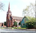
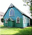
Pershore Road, Edgbaston, Birmingham 5
The green wooden building was originally St Agnes Church, Wake Green. Wake Green no longer exists, having been absorbed into the expanding "villages" of Moseley and Kings Heath in the early 1900s. Whilst a new St Agnes’ parish church was being built in Moseley the relevant authorities decided that this clapboard building was surplus to requirements. It was felt however, to be just what was needed here and as a result it was dismantled, transported and re-erected here near the junction of Pershore Road and Raglan Road. Space was left on its north-east side until a more permanent church could be built. A certain Lord Calthorpe eventually donated this corner site and the now adjacent Church of SS Mary & Ambrose was built in 1897-98 to a design by J.A. Chatwin of Birmingham. This cost of the red-brick and terracotta structure, i.e. £6000, was paid for by the Misses Stokes of The Hawthorns, Edgbaston. Thereafter the wooden clapboard building became the church hall for the Church of SS Mary & St Ambrose. The new parish, carved out of Edgbaston, was assigned in 1903. This Grade II-listed red-brick and terracotta church displaced St Bartholomew's mission church in Lower Edgbaston, a facility that had been built in 1885 to meet the needs of an expanding population.
Image: © David Hallam-Jones
Taken: 15 Apr 2019
0.08 miles
8
Shopping Parade, Hollies Croft
At the time of photographing, the car park is unusually empty and the street has just been swept. So the parade looks presentable.
Image: © Paul Collins
Taken: 4 Jul 2023
0.08 miles
9
Church Hall, St Mary & St Ambrose.
This church hall stands on the busy Pershore Road next to the Parish Church of the same name. Edgbaston Cricket ground is less than half a mile away.
Image: © Roy Hughes
Taken: 3 Feb 2009
0.09 miles
10
Pershore Road, Edgbaston, Birmingham 5
This green wooden building was originally St Agnes Church, Wake Green. Wake Green no longer exists, having been absorbed into the expanding "villages" of Moseley and Kings Heath in the early 1900s. Whilst a new St Agnes’ parish church was being built in Moseley the relevant authorities decided that this clapboard building was surplus to requirements. It was felt however, to be just what was needed here and as a result it was dismantled, transported and re-erected here near the junction of Pershore Road and Raglan Road. Space was left on its north-east side until a more permanent church could be built. A certain Lord Calthorpe eventually donated this corner site and the now adjacent Church of SS Mary & Ambrose (glimpsed beyond) was built in 1897-98 to a design by J.A. Chatwin of Birmingham. The cost of the red-brick and terracotta structure, i.e. £6000, was paid for by the Misses Stokes of The Hawthorns, Edgbaston. Thereafter the wooden clapboard building became the church hall for the Church of SS Mary & St Ambrose. The new parish, carved out of Edgbaston, was assigned in 1903. This Grade II-listed red-brick and terracotta church displaced St Bartholomew's mission church in Lower Edgbaston, a facility that had been built in 1885 to meet the needs of an expanding population.
Image: © David Hallam-Jones
Taken: 15 Apr 2019
0.09 miles


