IMAGES TAKEN NEAR TO
B5 6RQ
Introduction
This page details the photographs taken nearby to B5 6RQ by members of the Geograph project.
The Geograph project started in 2005 with the aim of publishing, organising and preserving representative images for every square kilometre of Great Britain, Ireland and the Isle of Man.

There are currently over 7.5m images from over14,400 individuals and you can help contribute to the project by visiting https://www.geograph.org.uk
Image Map
Images are licensed for reuse under creativecommons.org/licenses/by-sa/2.0
Notes
- Clicking on the map will re-center to the selected point.
- The higher the marker number, the further away the image location is from the centre of the postcode.
Image Listing (357 Images Found)
Images are licensed for reuse under creativecommons.org/licenses/by-sa/2.0
Image
Details
Distance
3
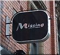
Missing
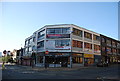
This bar is on the corner of Hurst Street and Bromsgrove Street,this was Formerly the Australian Bar.
Image: © Carl Baker
Taken: 14 Oct 2006
0.03 miles
4
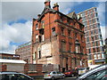
Derelict Building corner of Bromsgrove Street and Lower Essex Street
This lovely Victorian red brick buildings lies derelict on the corner of Bromsgrove Street and Lower Essex Street Birmingham. It is probably awaiting the fate of many similar buildings in Brum - to be knocked down and the site turned into new apartments.
Image: © Roy Hughes
Taken: 3 Jan 2009
0.03 miles
5
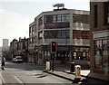
Junction of Hurst Street and Bromsgrove Street, Birmingham
Image: © habiloid
Taken: 2 Mar 2013
0.03 miles
6
Derelict building at the corner of Lower Essex Street and Bromsgrove Street, Birmingham
Image: © habiloid
Taken: 2 Mar 2013
0.03 miles
7
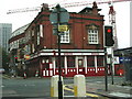
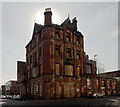
Former pub, Bromsgrove Street, Birmingham
There is something sublime about this lofty former pub, possibly enhanced by its dereliction. Built in 1900 by William Jenkins.
Until 1958 it was the Rose and Crown. The surrounding area has been built up as new housing since this photo, and it is likely to be renovated, apparently at the expense of everything but the facade.
Image: © Stephen Richards
Taken: 23 Jun 2015
0.03 miles
8
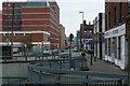
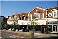
Bromsgrove St Birmingham
View NE along Bromsgrove St from the Bristol Rd just south of the city centre.
Image: © Nigel Mykura
Taken: 28 Feb 2009
0.03 miles
10
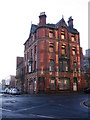
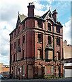
Old Brum new Brum new angle - Birmingham
This tall and still imposing building standing at the junction of Bromsgrove Street and Lower Essex Street is Unity House, the left-hand part of which has been demolished as it was unsafe. Previous to 1958 it was the Rose and Crown public house and later served as the regional hadquarters of a number of trade unions. It is Grade B locally listed but its future, whether for renovation or demolition, is not settled as far as I know. Behind it is new Brum - the I-land apartment building. Boasting 272 apartments within its mass, it is just short of 102 feet high and was completed in 2008, the work being undertaken by Crosby Homes. Time photo taken 10.49 am BST (British Summer Time).
Image: © Martin Richard Phelan
Taken: 20 May 2015
0.03 miles