IMAGES TAKEN NEAR TO
Floodgate Street, BIRMINGHAM, B5 5SS
Introduction
This page details the photographs taken nearby to Floodgate Street, B5 5SS by members of the Geograph project.
The Geograph project started in 2005 with the aim of publishing, organising and preserving representative images for every square kilometre of Great Britain, Ireland and the Isle of Man.

There are currently over 7.5m images from over14,400 individuals and you can help contribute to the project by visiting https://www.geograph.org.uk
Image Map (Loading...)


Getting Data...Please wait
Leaflet Map data © OpenStreetMap
Images are licensed for reuse under creativecommons.org/licenses/by-sa/2.0
Notes
- Clicking on the map will re-center to the selected point.
- The higher the marker number, the further away the image location is from the centre of the postcode.
Image Listing (353 Images Found)
Images are licensed for reuse under creativecommons.org/licenses/by-sa/2.0
Image
Details
Distance
1
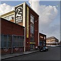
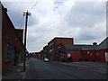
Birmingham Screwdriver Company building, Digbeth
The factory of the former Birmingham Screwdriver Company is now advertised as studio and office space, while Katjes (Katjes Fassin UK) make confectionery and other specialised products using 3-D printing in their 'magic candy factory' https://digbeth.com/directory/katjes-fassin-uk-1 , all of which reflects the shift away from metal trades to 'creative industries' in this part of town. The preserved ghost sign with its arm and hammer recall the crest on the Birmingham coat of arms Image The building stands at the corner of Floodgate Street and Little Ann Street.
This Historic England e-publication on Digbeth & Deritend https://historicengland.org.uk/research/results/reports/7279/DigbethandDeritendBirminghamWestMidlands_OutlineHistoricAreaAssessment shows, however, on p93, a photo of this building taken in 2017 with no evidence of the 'ghost sign', which suggests that it is a recent postmodern joke, 'Birmingham screwdriver' as a humorous term for a hammer. Historic England describe the building on p94 as the number 4 works of the W.J. Wild component manufacture factory, erected between 1955 and 1967. It appears to have been a metal pressing factory, so the comments above about change of use still stand.
Image: © A J Paxton
Taken: 22 Mar 2022
0.01 miles
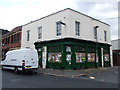
3
The Eagle, Digbeth
Formerly the Floodgate Tavern.
Image: © Chris Whippet
Taken: 28 Jul 2012
0.01 miles
4
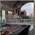
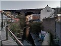
Footbridge over the River Rea, Digbeth
The footbridge forms part of a path connecting Gibb Street and Floodgate Street. The path runs entirely underneath the railway viaduct, passing through arches, one of which is visible at the left of this photo. Path and bridge are well-used, as they are located in the hip 'creative' and nightlife quarter around the Custard Factory. We are looking downstream, to the northeast; in the distance can be seen the former factory of the Birmingham Screwdriver Company, with its arm and hammer symbol Image
Like many urban rivers, the Rea (which rhymes with 'day') has suffered pollution and neglect and has been hidden away in culverts, but is now beginning to be rediscovered and appreciated once more.
Image: © A J Paxton
Taken: 22 Mar 2022
0.01 miles
5
River Rea viewed from Floodgate Street, Digbeth
The Rea, which rhymes with 'day', is the river of central Birmingham. It rises in the Waseley Hills country park in Worcestershire and flows northeast into the River Tame. Most of its 14 miles (23km) lie within the boundaries of the city of Birmingham, which has its origins in a medieval settlement which grew up around the Rea at Digbeth, a street which is believed to derive its name from 'dyke path' (see Wikipedia on the Rea https://en.wikipedia.org/wiki/River_Rea and on Digbeth https://en.wikipedia.org/wiki/Digbeth ). By the 18th century the focus of the town centre had shifted to the hillside to the northwest, around New Street, where it remains today. Digbeth continued to flourish as an industrial area, dominated since the mid-19th century by the blue-brick viaduct that carries the railway into Moor Street and Snow Hill stations.
The river has flooded frequently, hence the name Floodgate Street. It is seen here looking upstream to the southwest. The Custard Factory, former home of Bird's custard powder, is the cream-painted building visible through an arch of the viaduct.
Image: © A J Paxton
Taken: 22 Mar 2022
0.02 miles
7
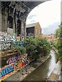
River Rea, Digbeth
The river on which Birmingham was founded makes a brief reappearance under the railway viaduct behind the Custard Factory.
Image: © Mike Parker
Taken: 30 Oct 2022
0.03 miles
8
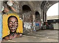
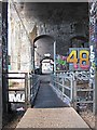
Underneath the arches
There is a great deal of superb street art under the viaduct behind the Custard Factory.
Image: © Mike Parker
Taken: 30 Oct 2022
0.03 miles
9

Custard Factory lights
A view of some of the office buildings in the Custard Factory, Digbeth.
Image: © Richard Harrison
Taken: 12 Dec 2005
0.04 miles
10
Gibb Street Car Park, Deritend, Birmingham 5
This footbridge links "The Custard Factory" (a business enterprise complex) car park on this side of the culverted River Rea with a further parking area that vehicles can only access from Floodgate Street. Trains services between Moor Street Station and Bordesley Station are carried over this area by an overhead viaduct.
Image: © David Hallam-Jones
Taken: 23 Feb 2019
0.04 miles