IMAGES TAKEN NEAR TO
Thorp Street, BIRMINGHAM, B5 4AT
Introduction
This page details the photographs taken nearby to Thorp Street, B5 4AT by members of the Geograph project.
The Geograph project started in 2005 with the aim of publishing, organising and preserving representative images for every square kilometre of Great Britain, Ireland and the Isle of Man.

There are currently over 7.5m images from over14,400 individuals and you can help contribute to the project by visiting https://www.geograph.org.uk
Image Map (Loading...)


Getting Data...Please wait
Leaflet Map data © OpenStreetMap
Images are licensed for reuse under creativecommons.org/licenses/by-sa/2.0
Notes
- Clicking on the map will re-center to the selected point.
- The higher the marker number, the further away the image location is from the centre of the postcode.
Image Listing (1036 Images Found)
Images are licensed for reuse under creativecommons.org/licenses/by-sa/2.0
Image
Details
Distance
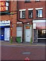
1
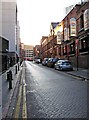
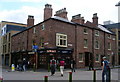
Thorp Street
Almost all of what can be seen on the right-hand side of the street, in this view, is part of the former 1st Warwickshire Rifle Volunteers Barracks. Image
Image: © P L Chadwick
Taken: 20 Dec 2009
0.01 miles
2
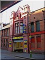
Thorp Street Car Park (formerly First Warwickshire Rifle Volunteers Barracks), 17 Thorpe Street
The garish signs of Euro Car Parks rather hide the fact that this is a very interesting building, originally built for the 1st Warwickshire Rifle Volunteers, who were a predecessor of the Territorial Army. The building was completed in November 1881, when the Corps moved here from the Bingley Hall, which they had previously used. Later the building was to become barracks of The Royal Warwickshire Regiment, which was part of the regular army.
Euro Car Parks use the main entrance to give access to the large yard at the back. This was presumably the drill yard, and is what is now used for car parking. Above the entrance are the words "1st Warwickshire Rifle Volunteers". Higher up the building are two crests. The barracks stretches a long way along Thorp Street, on both sides of this entrance. It is now divided into sections and parts are used by an accountants, a bar, a Chinese restaurant amongst other uses. See:- Image and Image
Image: © P L Chadwick
Taken: 20 Dec 2009
0.01 miles
3
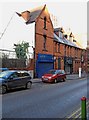
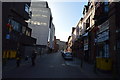
Victorian buildings in Thorp Street
These buildings appear to have originally been part of the large barracks complex at 17 Thorp Street. Today the one on the left is the office of RSW, a firm of chartered accountants. That on the right is StageSide, a modern restaurant and bar. The name originates from the fact that it is opposite the stage door of Birmingham's famous Hippodrome theatre.
To the left of the accountants is a site, which was at one time occupied by one of Birmingham's famous "courts" - cramped housing which fronted onto a communal courtyard, with various communal facilities. Apparently there were four housing units (for want of a better word) in this court. These were probably numbered 19, 21, 23 & 25 Thorp Street. All Birmingham's courts have been demolished except the one preserved by the National Trust in Inge Street/Hurst Street.
Image: © P L Chadwick
Taken: 20 Dec 2009
0.01 miles
4
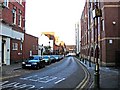
Thorp Street
In some documents it is spelt Thorpe Street, but officially these days it seems to be spelt without the "e". The street includes the stage door to the famous Hippodrome Theatre, as well as an old voluntary rifle corps barracks, now used for assorted purposes. Image
Image: © P L Chadwick
Taken: 20 Dec 2009
0.01 miles
5
The Back to Backs
An oasis of history in modern development
Image: © Andrew Darge
Taken: 1 Sep 2006
0.01 miles
8
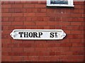
Thorp Street (road name sign)
What is interesting about this sign is the ornate design. Presumably this is an original Victorian name sign. Note also the ",," characters under the "t" of "St" to indicate the word has been contracted. This isn't something you would be likely to find in a modern sign and, if you did, these days it would be shown as ".,". There are quite a few of these traditional name signs still displayed in the city's older streets. Thorp Street itself, has another one at the other end of the road.
In some documents, Thorp is spelt Thorpe. The spacing on the road name sign would allow for an "e" at the end of Thorp, so maybe this was removed at some point? Image
Image: © P L Chadwick
Taken: 20 Dec 2009
0.02 miles
9
Odds and ends in Thorp Street
There are several things worth noting in this photograph of a small section of one of Birmingham's remaining Victorian streets. First the elegant street light, which is an attractive traditional design, though it may be a replica rather than an original. The colours make a pleasant change from the black & gold used a little too often elsewhere. To its right, is a matching street bollard. In between is a definitely non-Victorian wheelie bin. Above this is another of Birmingham's traditional road name signs. What is interesting about this, is that it is shorter then the one at the other end of the street, and unlike that, there is no space for an "e" at the end of "Thorp". So was this a later sign, after the street name appeared to have changed its spelling, or did the person making the other sign make a mistake and then have to remove the "e"? The other sign:- Image
Image: © P L Chadwick
Taken: 20 Dec 2009
0.02 miles
10
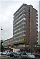
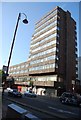
Albany House, Hurst Street, Birmingham
Built in 1963-65 by Marshman & Warren. Clad in dark brown concrete.
Image: © Stephen Richards
Taken: 26 Aug 2011
0.03 miles