IMAGES TAKEN NEAR TO
Bramley Way, ALCESTER, B50 4QG
Introduction
This page details the photographs taken nearby to Bramley Way, B50 4QG by members of the Geograph project.
The Geograph project started in 2005 with the aim of publishing, organising and preserving representative images for every square kilometre of Great Britain, Ireland and the Isle of Man.

There are currently over 7.5m images from over14,400 individuals and you can help contribute to the project by visiting https://www.geograph.org.uk
Image Map (Loading...)


Getting Data...Please wait
Leaflet Map data © OpenStreetMap
Images are licensed for reuse under creativecommons.org/licenses/by-sa/2.0
Notes
- Clicking on the map will re-center to the selected point.
- The higher the marker number, the further away the image location is from the centre of the postcode.
Image Listing (35 Images Found)
Images are licensed for reuse under creativecommons.org/licenses/by-sa/2.0
Image
Details
Distance
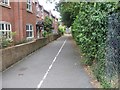
1
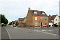
Bramley Way at St Laurence Way, Bidford-on-Avon
Image: © Roy Hughes
Taken: 23 Jul 2022
0.01 miles
5
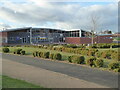
Bidford-on-Avon C of E Primary School
In addition to school this building houses a community library and the Parish Council office. I would regard that as exceptionally good use of the space. Seen through the perimeter fence.
Image: © Chris Allen
Taken: 12 Dec 2020
0.07 miles
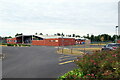

10

Charity recycling bins at Bidford-on-Avon fire station
Image: © Rod Allday
Taken: 25 Sep 2019
0.14 miles