IMAGES TAKEN NEAR TO
Rush Lane, ALCESTER, B50 4ER
Introduction
This page details the photographs taken nearby to Rush Lane, B50 4ER by members of the Geograph project.
The Geograph project started in 2005 with the aim of publishing, organising and preserving representative images for every square kilometre of Great Britain, Ireland and the Isle of Man.

There are currently over 7.5m images from over14,400 individuals and you can help contribute to the project by visiting https://www.geograph.org.uk
Image Map
Images are licensed for reuse under creativecommons.org/licenses/by-sa/2.0
Notes
- Clicking on the map will re-center to the selected point.
- The higher the marker number, the further away the image location is from the centre of the postcode.
Image Listing (4 Images Found)
Images are licensed for reuse under creativecommons.org/licenses/by-sa/2.0
Image
Details
Distance
1
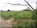
Vale produce - asparagus
Bridleway across field near Broom Court.
Image: © Liz Stone
Taken: 20 Aug 2011
0.14 miles
2
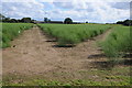
Asparagus field
With the asparagus coming to a close last week this field has been left to regenerate ready for next years crop. This field is viewed from the footpath on the southern side of the bridge over the long closed railway. The farm buildings at Broom Court can be seen in the background.
Image: © Philip Halling
Taken: 30 Jun 2012
0.18 miles
3
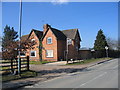
Broom Court Farm
At the start of the driveway to Broom Court.
Image: © David Stowell
Taken: 4 Mar 2006
0.20 miles
4
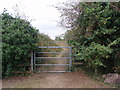
Bridleway gate on path over old railway line
Near Broom junction of former lines.
Image: © Liz Stone
Taken: 20 Aug 2011
0.21 miles