IMAGES TAKEN NEAR TO
Tything Road East, ALCESTER, B49 6EX
Introduction
This page details the photographs taken nearby to Tything Road East, B49 6EX by members of the Geograph project.
The Geograph project started in 2005 with the aim of publishing, organising and preserving representative images for every square kilometre of Great Britain, Ireland and the Isle of Man.

There are currently over 7.5m images from over14,400 individuals and you can help contribute to the project by visiting https://www.geograph.org.uk
Image Map (Loading...)


Getting Data...Please wait
Leaflet Map data © OpenStreetMap
Images are licensed for reuse under creativecommons.org/licenses/by-sa/2.0
Notes
- Clicking on the map will re-center to the selected point.
- The higher the marker number, the further away the image location is from the centre of the postcode.
Image Listing (9 Images Found)
Images are licensed for reuse under creativecommons.org/licenses/by-sa/2.0
Image
Details
Distance
1

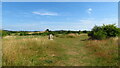
Arden Forest Industrial Estate
Industrial estate to the north of Alcester, viewed here from the footpath to the east.
Image: © Philip Halling
Taken: 22 May 2010
0.06 miles
2

The Monarch's Way approaching Alcester.
Arden Forest Industrial Estate on the right.
Image: © Tim Heaton
Taken: 22 Jun 2013
0.15 miles
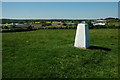
3

Trig point east of Alcester
From here the Monarch's Way crosses the dense hedge in the middle distance (the route of an old railway line) and follows the ridge past the tree in the middle of the horizon
Image: © Tim Heaton
Taken: 22 Jun 2013
0.16 miles
4

Parapet of former railway bridge
Now just a footpath and quite overgrown.
Image: © Liz Stone
Taken: 25 Mar 2012
0.18 miles
5

Arden Forest Industrial Estate
View from the slight rise holding the Kinwarton trigpoint of this Alcester industrial estate.
Image: © Richard Webb
Taken: 13 Jan 2004
0.20 miles
6

Course of the old Alcester Railway
This used to be a cutting and has possibly been used at some time as a landfill site, here it is viewed from an old railway bridge carrying a footpath.
Image: © Philip Halling
Taken: 22 May 2010
0.23 miles
7

The Arrow valley
View across the Arrow valley from the Arden Way.
Image: © Philip Halling
Taken: 22 May 2010
0.24 miles
8
On the Arden Way & trig point NE of Alcester
Image: © Colin Park
Taken: 16 Jul 2022
0.24 miles
9
Trig point above Alcester
This trig point just to the north of Alcester has had a coat of paint since Richard Webb photographed it six years ago. The Arden Forest Industrial Estate can be seen in the background, see: Image
Image: © Philip Halling
Taken: 22 May 2010
0.25 miles