IMAGES TAKEN NEAR TO
Ardens Grafton, ALCESTER, B49 6DS
Introduction
This page details the photographs taken nearby to B49 6DS by members of the Geograph project.
The Geograph project started in 2005 with the aim of publishing, organising and preserving representative images for every square kilometre of Great Britain, Ireland and the Isle of Man.

There are currently over 7.5m images from over14,400 individuals and you can help contribute to the project by visiting https://www.geograph.org.uk
Image Map
Images are licensed for reuse under creativecommons.org/licenses/by-sa/2.0
Notes
- Clicking on the map will re-center to the selected point.
- The higher the marker number, the further away the image location is from the centre of the postcode.
Image Listing (24 Images Found)
Images are licensed for reuse under creativecommons.org/licenses/by-sa/2.0
Image
Details
Distance
1
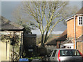
A cramped domestic space, Ardens Grafton
The brick cottage is atypical. Most of the village is built of lias, blue and buff. The tree is ash, characteristic on limestone. 'British History Online' says that there was once extensive quarrying of high quality building stone in the Grafton district, but in the later 19th century the industry began to decline and has now quite disappeared. The only clue to this on the 1:25 000 map is Quarry Wood in Image
Image: © Robin Stott
Taken: 13 Jan 2011
0.01 miles
2
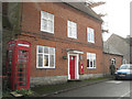
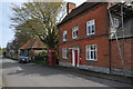
The Old Post Office, Ardens Grafton
The house is of blue lias stone with a brick facade. Both the house and the K6 telephone kiosk are listed grade II, along with several other buildings in the village. Postbox number B49 85.
Image: © Robin Stott
Taken: 13 Jan 2011
0.01 miles
3
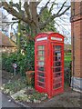
K6 Telephone Box, Ardens Grafton
The telephone box outside The Old Post Office in Ardens Grafton.
The K6 box is grade 2 listed. http://www.britishlistedbuildings.co.uk/en-483165-k6-telephone-kiosk-outside-the-old-post-
Image: © David P Howard
Taken: 4 Feb 2013
0.02 miles
4
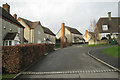
Houses in Ardens Grafton
Houses and cottages in the village of Ardens Grafton.
Image: © Philip Halling
Taken: 2 Apr 2011
0.02 miles
5
Ardens Grafton
House in the village of Ardens Grafton.
Image: © Philip Halling
Taken: 2 Apr 2011
0.02 miles
6
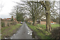
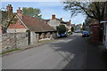
Cox's Walk, Ardens Grafton
Cox's Walk runs along the crest of a lias ridge.
Image: © Robin Stott
Taken: 13 Jan 2011
0.06 miles
7
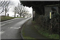
Bus stop, Ardens Grafton
Service 212 operated by Welcombe Garages calls here on Tuesdays and Fridays, according to the faded timetable. It's a circular route around the Avon valley west of Stratford. The photo gives a sense of how the village sits along a ridge. The wrought iron bar fencing is everywhere.
Image: © Robin Stott
Taken: 13 Jan 2011
0.07 miles
8
Vauxhall Lane, Ardens Grafton
Twentieth-century houses faced with local limestone.
Image: © Robin Stott
Taken: 13 Jan 2011
0.07 miles
9
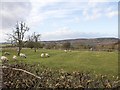
Ridge and furrow pasture, Ardens Grafton
A small ridge and furrow field with some grazing sheep at the west end of the village.
The large wood on the horizon is Oversley Wood centred on Image
Image: © David P Howard
Taken: 4 Feb 2013
0.08 miles
10
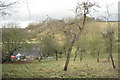
Orchard, Orchard Farm, Ardens Grafton
Grove Hill in the background. This type of landscape has been characterised as the vale orchard belt of the Avon valley.
Image: © Robin Stott
Taken: 13 Jan 2011
0.08 miles