IMAGES TAKEN NEAR TO
The Priory Queensway, BIRMINGHAM, B4 6FH
Introduction
This page details the photographs taken nearby to The Priory Queensway, B4 6FH by members of the Geograph project.
The Geograph project started in 2005 with the aim of publishing, organising and preserving representative images for every square kilometre of Great Britain, Ireland and the Isle of Man.

There are currently over 7.5m images from over14,400 individuals and you can help contribute to the project by visiting https://www.geograph.org.uk
Image Map (Loading...)


Getting Data...Please wait
Leaflet Map data © OpenStreetMap
Images are licensed for reuse under creativecommons.org/licenses/by-sa/2.0
Notes
- Clicking on the map will re-center to the selected point.
- The higher the marker number, the further away the image location is from the centre of the postcode.
Image Listing (699 Images Found)
Images are licensed for reuse under creativecommons.org/licenses/by-sa/2.0
Image
Details
Distance
1
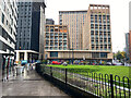
Exchange Square, Birmingham
The view is northwest from Masshouse Plaza across Moor Street Queensway. The short block looks like flats. The tall slab at the back is seen obliquely in Image
Image: © Robin Stott
Taken: 21 Oct 2022
0.02 miles
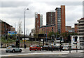
2
Junction of Dale End and Newton Street northeast of Priory Queensway
Dale End passes under Priory Queensway, foreground. The city centre's location on the crest of a ridge results in some lively differences of level. The Crown Court noses round the corner of the dark far building; to its right are buildings in Aston University. The building on the very left of the picture is Bannatyne's Health Club and Spa.
Image: © Robin Stott
Taken: 20 Oct 2012
0.03 miles
3
Coleshill Street and its junction with Chapel Street
In the second half of the 18th century a manufacturer of buckles, William Tutin, had a factory at 12 Coleshill Street, which was probably about here. No traces of ancient buildings remain, and most of the street is within the campus of Aston University.
In 1770 William Tutin patented "Tutania", an alloy of copper antimony zinc and tin, and used it in manufacturing various items. In the 1785 directory he is described as a "Manufacturer of fine white Tutania, Yellow and Pinchbeck Buckles, Tutania spoons, Coach furniture &c"
See also Image]
Image: © Rich Tea
Taken: 7 Feb 2007
0.03 miles
4
Exchange Circus development under way, Birmingham
At the junction of The Priory Queensway, centre left, and Moor Street Queensway, formerly Masshouse Circus. Photographed through a third floor window.
Image: © Robin Stott
Taken: 19 Dec 2016
0.04 miles
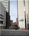
6
Crown Court, Dalton Street, Birmingham
The view is down Newton Street.
Image: © Robin Stott
Taken: 10 Jul 2021
0.05 miles
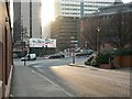
7
More high rise development in Birmingham
Another tall building being erected as viewed from Moor Street station. I think this is the same site as seen in Image
Image: © Stephen Craven
Taken: 18 Sep 2021
0.05 miles
8
McLaren Building, Dale End, Birmingham
A massive but quite slim slab, built in 1972 to the designs of Paul Bonham Associates. The exterior was renewed in 2009. Built for HSBC, now in multiple occupancy.
The work in front was adjacent to Image
Image: © Stephen Richards
Taken: 19 Mar 2012
0.05 miles
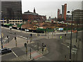
9
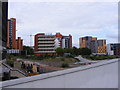
University View
The view from The Priory Queensway. Aston University on the left, Matthew Boulton College centre and Birmingham City University on the right.
Image: © Gordon Griffiths
Taken: 31 Aug 2009
0.05 miles
10
Aston University, Birmingham
Seen from Moor Street Queensway (B4100).
Image: © habiloid
Taken: 27 May 2013
0.05 miles