IMAGES TAKEN NEAR TO
BIRMINGHAM, B46 9BH
Introduction
This page details the photographs taken nearby to B46 9BH by members of the Geograph project.
The Geograph project started in 2005 with the aim of publishing, organising and preserving representative images for every square kilometre of Great Britain, Ireland and the Isle of Man.

There are currently over 7.5m images from over14,400 individuals and you can help contribute to the project by visiting https://www.geograph.org.uk
Image Map
Images are licensed for reuse under creativecommons.org/licenses/by-sa/2.0
Notes
- Clicking on the map will re-center to the selected point.
- The higher the marker number, the further away the image location is from the centre of the postcode.
Image Listing (119 Images Found)
Images are licensed for reuse under creativecommons.org/licenses/by-sa/2.0
Image
Details
Distance
1
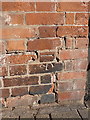
OS benchmark - Coleshill, Lloyd's Bank
An OS cutmark on the front wall of Lloyd's Bank; originally levelled at 101.036m above Ordnance Datum Newlyn.
Image: © Richard Law
Taken: 7 Feb 2017
0.02 miles
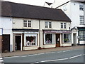
2
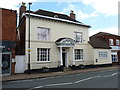
131 High Street, Coleshill - Queen Anne House
A rather fine early 18th century town house, which attracted a Grade II listing https://britishlistedbuildings.co.uk/101365204-queen-anne-house-and-attached-railings-coleshill#.W5oI0ehKhPY in 1942; the listing includes the slender railings to either side of the door hood and its columns. At the time of this image, it appears to be the offices of a model agency, but there's little on the outside to give that away from this distance.
Image: © Richard Law
Taken: 2 Aug 2018
0.02 miles
3
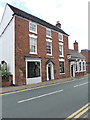
119 High Street, Coleshill
No 113 on the High Street is occupied by Lloyds Bank, but is originally a late 18th century town house which was Grade II listed https://britishlistedbuildings.co.uk/101034661-119-high-street-coleshill#.W5oHSuhKhPY in 1952. The listing includes the 19th century single storey extension along to the right.
Image: © Richard Law
Taken: 2 Aug 2018
0.02 miles
4
122 & 124 High Street, Coleshill
The Linen Box and Gascoigne Brothers cycles occupy nos 124 & 122 respectively, which are a pair of early 19th century shops, attracting a Grade II listing https://britishlistedbuildings.co.uk/101185686-122-and-124-high-street-coleshill#.W5oKUuhKhPY in 1989. The colonetted bay windows are original, although they would probably once have contained multi-paned sashes (similar to the grey ones seen in the building just to the right) rather than the modern single panes of plain glass.
Image: © Richard Law
Taken: 2 Aug 2018
0.03 miles
5
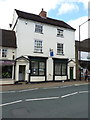
118 & 120 High Street, Coleshill
Originally built around 1800 as two houses, but currently the High Street's dental centre; attracted a Grade II listing https://britishlistedbuildings.co.uk/101034669-118-and-120-high-street-coleshill#.W5vja9QrLGg in 1952.
Image: © Richard Law
Taken: 2 Aug 2018
0.03 miles
6
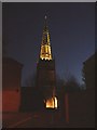
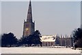
SS Peter & Paul, Coleshill - Floodlit
The magnificent spire of Coleshill's SS Peter & Paul's Church. Not only does this church possess a very fine, tall spire, but it is on top of a hill so that it is a landmark for miles around.
Image: © Rob Farrow
Taken: 21 Jan 2006
0.03 miles
7
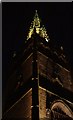
The Spire, SS Peter & Paul, Coleshill
An Up-the-spire shot of this superb steeple.
Image: © Rob Farrow
Taken: 21 Jan 2006
0.03 miles
8
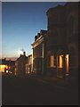
Church Hill, Coleshill
A rather "soft-focus" but quite atmospheric shot down Church Hill from alongside the church.
Image: © Rob Farrow
Taken: 21 Jan 2006
0.03 miles
9
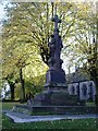
War Memorial
This memorial is in the church grounds of St Peter and St Paul's church on Church Hill Coleshill.
Image: © Carl Baker
Taken: 2 Nov 2006
0.03 miles