
IMAGES TAKEN NEAR TO
Coventry Road, BIRMINGHAM, B46 3EA
Introduction
This page details the photographs taken nearby to Coventry Road, B46 3EA by members of the Geograph project.
The Geograph project started in 2005 with the aim of publishing, organising and preserving representative images for every square kilometre of Great Britain, Ireland and the Isle of Man.

There are currently over 7.5m images from over14,400 individuals and you can help contribute to the project by visiting https://www.geograph.org.uk
Image Map
Images are licensed for reuse under creativecommons.org/licenses/by-sa/2.0
Notes
- Clicking on the map will re-center to the selected point.
- The higher the marker number, the further away the image location is from the centre of the postcode.
Image Listing (10 Images Found)
Images are licensed for reuse under creativecommons.org/licenses/by-sa/2.0
Image
Details
Distance
1
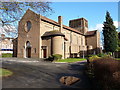
Coleshill Catholic Church
The church of the Sacred Heart and St Teresa lies on the east side of the main Coventry Road B4117 out of Coleshill. It was built between 1938 and 1942 to a design by George Bernard Cox of the architects Harrison & Cox, and was Grade II listed https://britishlistedbuildings.co.uk/101034700-roman-catholic-church-of-the-sacred-heart-and-st-teresa-and-two-pairs-of-gatepiers-coleshill#.W92J0NSLTGg in 1989. The two sets of gatepiers Image at the entranceways to the carpark are also part of that listing
Image: © Richard Law
Taken: 7 Feb 2017
0.01 miles
2
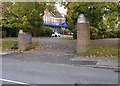
Listed gatepiers outside the church of the Sacred Heart and St Teresa
Grade II listed https://britishlistedbuildings.co.uk/101034700-roman-catholic-church-of-the-sacred-heart-and-st-teresa-and-two-pairs-of-gatepiers-coleshill#.W92J0NSLTGg, along with the main church building in 1989. There is another, identical, pair about 30 yards to the south of this point, but they less suitable for a photo as they are slightly overgrown by shrubbery.
Image: © Richard Law
Taken: 29 Oct 2018
0.04 miles
3

No 69 Coventry Road (Springfield House), Coleshill
A late 18th century town house, Grade II listed https://www.britishlistedbuildings.co.uk/101299640-69-coventry-road-coleshill#.Wt7OU_nwaM8 in 1989. Interior features of note include some wooden wall panelling, a fireplace with cast iron surround, and a late 18th century staircase.
Image: © Richard Law
Taken: 5 Apr 2018
0.07 miles

5
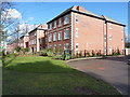
Dugdale Court, Coleshill
Retirement and sheltered accommodation living on the south side of Colehsill.
Image: © Richard Law
Taken: 7 Feb 2017
0.10 miles
6

George & Dragon Public House
Taken from entrance to Packington Lane Coleshill
Image: © John A Lainchbury
Taken: 3 May 2006
0.18 miles
7

Coventry Road approaching Packenham Lane junction
Image: © Peter Whatley
Taken: 16 Feb 2013
0.18 miles

9

Pound Cottage, Coleshill
Grade II listed https://www.britishlistedbuildings.co.uk/101185707-pound-cottage-coleshill#.Wt7PZfnwaM8 in 1972, this timber-framed cottage dates to the 17th century, and retains its thatched roof and presumably a number of interesting internal features.
Image: © Richard Law
Taken: 5 Apr 2018
0.21 miles
10

Coleshill
The thatched cottage in the V of the junction with Packington Lane.
Image: © David Stowell
Taken: 1 Sep 2006
0.22 miles