IMAGES TAKEN NEAR TO
Nuneaton Road, BIRMINGHAM, B46 2NL
Introduction
This page details the photographs taken nearby to Nuneaton Road, B46 2NL by members of the Geograph project.
The Geograph project started in 2005 with the aim of publishing, organising and preserving representative images for every square kilometre of Great Britain, Ireland and the Isle of Man.

There are currently over 7.5m images from over14,400 individuals and you can help contribute to the project by visiting https://www.geograph.org.uk
Image Map
Images are licensed for reuse under creativecommons.org/licenses/by-sa/2.0
Notes
- Clicking on the map will re-center to the selected point.
- The higher the marker number, the further away the image location is from the centre of the postcode.
Image Listing (3 Images Found)
Images are licensed for reuse under creativecommons.org/licenses/by-sa/2.0
Image
Details
Distance
1
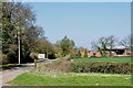
Private drive to Laxe's Farm, Estate House and Keepers Cottage
Image: © Mick Malpass
Taken: 1 Apr 2012
0.14 miles
2
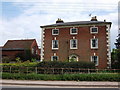
Monwode House Farm
Late 18th century, listed Grade II.
http://list.english-heritage.org.uk/resultsingle.aspx?uid=1115604
Also see Monwode Lea farmhouse nearby.Image]
Image: © John Brightley
Taken: 18 May 2010
0.16 miles
3
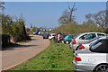
Car parking for Furnace End Car Boot Sale
Over Whitacre church can be seen in the background.
Image: © Mick Malpass
Taken: 1 Apr 2012
0.17 miles