IMAGES TAKEN NEAR TO
The Green, BIRMINGHAM, B46 2AR
Introduction
This page details the photographs taken nearby to The Green, B46 2AR by members of the Geograph project.
The Geograph project started in 2005 with the aim of publishing, organising and preserving representative images for every square kilometre of Great Britain, Ireland and the Isle of Man.

There are currently over 7.5m images from over14,400 individuals and you can help contribute to the project by visiting https://www.geograph.org.uk
Image Map
Images are licensed for reuse under creativecommons.org/licenses/by-sa/2.0
Notes
- Clicking on the map will re-center to the selected point.
- The higher the marker number, the further away the image location is from the centre of the postcode.
Image Listing (14 Images Found)
Images are licensed for reuse under creativecommons.org/licenses/by-sa/2.0
Image
Details
Distance
1
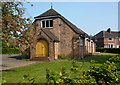
Shustoke Parish Hall
At the junction of Church Road (B4114) and The Green.
Image: © Andrew Hill
Taken: 30 Apr 2011
0.12 miles
2
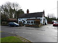
The Plough, Shustoke
The village pub dates from 1790, and sits just to the south of Church Road through the village.
Image: © Richard Law
Taken: 29 Jan 2018
0.13 miles
3

Shustoke village
Shustoke village, a pub and a cycle repair shop...what more do you need?
Image: © Richard Harrison
Taken: 20 Jan 2006
0.13 miles
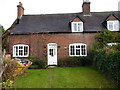
4
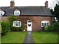
Rose Cottage, Shustoke
The right-hand/southern half of a pair of semi-detached 19th century cottages which were given a single Grade II listing https://www.britishlistedbuildings.co.uk/101034802-rose-cottage-and-cottage-adjoining-shustoke#.WnF2Kfll-M8 in 1988. The other half is formed by Image
Image: © Richard Law
Taken: 29 Jan 2018
0.14 miles
5
Rose Tree cottages. Shustoke
Another view of the pair of 19th century Grade II listed https://www.britishlistedbuildings.co.uk/101034802-rose-cottage-and-cottage-adjoining-shustoke#.WnF7lPll-M8 cottages just north of Image
Image: © Richard Law
Taken: 29 Jan 2018
0.14 miles
6
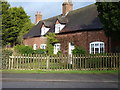
Rose Tree Cottage, Shustoke
The north/left half of a pair of semi-detached 19th century cottages, given a Grade II listing https://www.britishlistedbuildings.co.uk/101034802-rose-cottage-and-cottage-adjoining-shustoke#.WnF2Kfll-M8 in 1988. The other half is at Image
Image: © Richard Law
Taken: 29 Jan 2018
0.14 miles
7
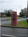
K6 telephone box in Shustoke
Grade II listed https://www.britishlistedbuildings.co.uk/101226486-k6-telephone-kiosk-shustoke in 1994, the box sits on the green in the village.
Image: © Richard Law
Taken: 29 Jan 2018
0.14 miles
8
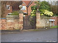
Gateway to Priory Farmhouse
Each gatepier and its adjoining sandstone wall holds its own Grade II listing https://www.britishlistedbuildings.co.uk/101320405-gatepier-and-sandstone-part-of-adjoining-forecourt-wall-on-west-side-of-entry-to-priory-farmhouse-shustoke#.WnFyRvll-M8 and https://www.britishlistedbuildings.co.uk/101365120-gatepier-and-sandstone-part-of-adjoining-forecourt-wall-on-east-side-of-entry-to-priory-farmhouse-shustoke#.WnFyTPll-M8 both of which were granted in 1988. They date from the very early 18th century, and it seems likely that the wall originally extended further east and west, now rebuilt in brick.
Priory Farmhouse behind is II* listed.
Image: © Richard Law
Taken: 29 Jan 2018
0.15 miles
9
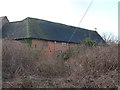
Green Farm barn, Shustoke
A late 17th century barn, Grade II listed https://www.britishlistedbuildings.co.uk/101365119-barn-20-metres-north-east-of-green-farmhouse-shustoke#.WnF4x_ll-M8 in 19888. At the time of listing it was described as 'converted to a cow byre' but may well have been converted subsequently to residential use (it's hard to get close enough to tell)
Image: © Richard Law
Taken: 29 Jan 2018
0.15 miles
10
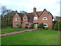
Priory Farmhouse, Shustoke
The late 18th century brick covering hides a remarkable early 15th century, timber framed cruck-built open hall house which was given a Grade II* listing https://www.britishlistedbuildings.co.uk/101320436-priory-farmhouse-shustoke#.WnFzZvll-M8 in 1988. It is currently operated as a B&B business.
Image: © Richard Law
Taken: 29 Jan 2018
0.16 miles