IMAGES TAKEN NEAR TO
Stonecross, BIRMINGHAM, B46 1NA
Introduction
This page details the photographs taken nearby to Stonecross, B46 1NA by members of the Geograph project.
The Geograph project started in 2005 with the aim of publishing, organising and preserving representative images for every square kilometre of Great Britain, Ireland and the Isle of Man.

There are currently over 7.5m images from over14,400 individuals and you can help contribute to the project by visiting https://www.geograph.org.uk
Image Map
Images are licensed for reuse under creativecommons.org/licenses/by-sa/2.0
Notes
- Clicking on the map will re-center to the selected point.
- The higher the marker number, the further away the image location is from the centre of the postcode.
Image Listing (51 Images Found)
Images are licensed for reuse under creativecommons.org/licenses/by-sa/2.0
Image
Details
Distance
1
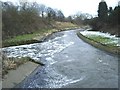
River Tame, Water Orton
View of river from old road bridge crossing, close to outlet (on left) from nearby sewerage works. Looking east Image
Image: © Michael Westley
Taken: 20 Feb 2010
0.04 miles
2
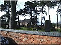
Church yard, Old Church Road, Water Orton
No church remains at the site, but new homes have been built surrounding this small church yard/cemetery on Old Church Road.
Image: © Michael Westley
Taken: 19 Feb 2010
0.05 miles
3
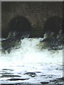
Gushing Forth, Water Orton
A steady heavy flow of water exits into River Tame from the Severn Trent sewerage works north of Water Orton. See Image]
Image: © Michael Westley
Taken: 20 Feb 2010
0.05 miles
4
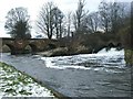
Full flush, Water Orton
View from alongside River Tame, where old narrow road bridge crosses, and full force of water exiting from Sewerage Works can be seen on the right.
Image: © Michael Westley
Taken: 20 Feb 2010
0.05 miles
5

Medieval cross in old churchyard
Located within the bounds of Image, this 15th century cross shaft was Grade II listed https://britishlistedbuildings.co.uk/101365202-cross-at-sp-1760-9121-water-orton#.W-WgvNSLTGg in 1961.
Image: © Richard Law
Taken: 24 Sep 2018
0.05 miles
6

Wakefield House, Water Orton
In parts thought to be early 16th century, albeit with 17th century alterations. There is extensive timber framing to both wings of the house, which was Grade II listed https://britishlistedbuildings.co.uk/101186242 in 1952.
Image: © Richard Law
Taken: 24 Sep 2018
0.05 miles
8
Manor House Lane, Water Orton
Narrow residential road in village.
Image: © Michael Westley
Taken: 19 Feb 2010
0.06 miles
9
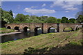
Water Orton Bridge
This is a historical bridge over the river Tame, built around 1520 to replace an earlier one.
Image: © Paul
Taken: 7 May 2009
0.07 miles
10

Along Water Orton bridge
A modern roadway across a very old bridge.
Image: © Richard Law
Taken: 24 Sep 2018
0.07 miles