IMAGES TAKEN NEAR TO
Privet Close, BIRMINGHAM, B44 9HG
Introduction
This page details the photographs taken nearby to Privet Close, B44 9HG by members of the Geograph project.
The Geograph project started in 2005 with the aim of publishing, organising and preserving representative images for every square kilometre of Great Britain, Ireland and the Isle of Man.

There are currently over 7.5m images from over14,400 individuals and you can help contribute to the project by visiting https://www.geograph.org.uk
Image Map
Images are licensed for reuse under creativecommons.org/licenses/by-sa/2.0
Notes
- Clicking on the map will re-center to the selected point.
- The higher the marker number, the further away the image location is from the centre of the postcode.
Image Listing (24 Images Found)
Images are licensed for reuse under creativecommons.org/licenses/by-sa/2.0
Image
Details
Distance
1
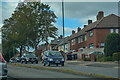
Kingstanding : Kings Road B4149
Looking along Kings Road.
Image: © Lewis Clarke
Taken: 26 Sep 2020
0.12 miles
2
Kingstanding : Cotleigh Grove
Looking off Queslett Road.
Image: © Lewis Clarke
Taken: 26 Sep 2020
0.13 miles
4
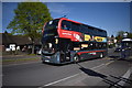
Bus to West Bromwich - Kingstanding, North Birmingham
An NXWM - National Express West Midlands - bus on Kings Road, Kingstanding having just passed the junction with Shady Lane. This vehicle is on the no. (number) 5 route from Sutton Coldfield to West Bromwich via Kingstanding, Great Barr and Newton. This route was once numbered 451. Bus, train and tram services here were part of Network West Midlands until, I cannot understand why, it became West Midlands Network and was given a new logo. Time photo taken 2.58 pm BST (British Summer Time). Image]
Image: © Martin Richard Phelan
Taken: 21 Apr 2020
0.14 miles
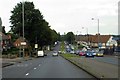
5
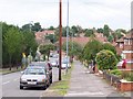
Kings Road north-west - Kingstanding, North Birmingham
This photo taken at the junction of Kings Road with, to the left Shady Lane. The B4149 Kings Road connects the A4041 Queslett Road Image with the A452 Chester Road/Chester Road North at New Oscott Image The National Express West Midlands no. (number) 5 bus in the photo runs between Sutton Coldfield and West Bromwich providing an 'every few minutes' service. Time photo taken 9.52 am GMT (Greenwich Mean Time).
Image: © Martin Richard Phelan
Taken: 5 Feb 2020
0.14 miles
6
Gailey Croft - Kingstanding, North Birmingham
Leading north-west off Shady Lane is Gailey Croft, a residential cul-de-sac named, I assume, after Gailey in Staffordshire which sits astride the A5 road Image which runs to Holyhead in North Wales. On the right is the Apollo Surgery - entrance around the corner on Kings Road. Time photo taken 2.13 pm GMT (Greenwich Mean Time).
Image: © Martin Richard Phelan
Taken: 7 Jan 2020
0.15 miles
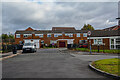
8
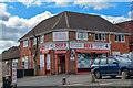
Kingstanding : Sid's Wines
Sid's Wines on Shady Lane.
Image: © Lewis Clarke
Taken: 26 Sep 2020
0.15 miles
9
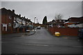
Not so shady now - Kingstanding, North Birmingham
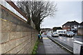
This is a view south-south-west on Shady Lane near its junction with Kings Road. Not so shady now, if it ever was, it connects the B4149 Kings Road with Aldridge Road Image Time photo taken 2.11 pm GMT (Greenwich Mean Time).
Image: © Martin Richard Phelan
Taken: 7 Jan 2020
0.15 miles
10
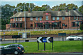
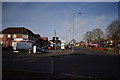
Kingstanding : Roundabout
A roundabout with Buffet Island in view.
Image: © Lewis Clarke
Taken: 26 Sep 2020
0.15 miles