IMAGES TAKEN NEAR TO
Templeton Road, BIRMINGHAM, B44 9DA
Introduction
This page details the photographs taken nearby to Templeton Road, B44 9DA by members of the Geograph project.
The Geograph project started in 2005 with the aim of publishing, organising and preserving representative images for every square kilometre of Great Britain, Ireland and the Isle of Man.

There are currently over 7.5m images from over14,400 individuals and you can help contribute to the project by visiting https://www.geograph.org.uk
Image Map
Images are licensed for reuse under creativecommons.org/licenses/by-sa/2.0
Notes
- Clicking on the map will re-center to the selected point.
- The higher the marker number, the further away the image location is from the centre of the postcode.
Image Listing (21 Images Found)
Images are licensed for reuse under creativecommons.org/licenses/by-sa/2.0
Image
Details
Distance
1
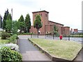
Our Lady of the Assumption, Old Oscott Hill
a.k.a. Maryvale Church. This is one of the main centres of Roman Catholic activity in Birmingham. Also on this site are the convent and the secondary school.
Image: © Adrian Bailey
Taken: 17 Jun 2005
0.14 miles
2
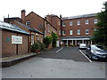
The Maryvale Institute in Oscott
The oldest part of this unusual building dates from 1752, when it was built for the local Roman Catholic Bishop Thomas Hornyhold, but it's been altered and extended plenty in the meantime. The whole construction was given a Grade II* listing https://britishlistedbuildings.co.uk/101076213-maryvale-institute-oscott-ward#.W6eIQNQrLGg in 1995. To quote a small portion of the listing text:- "Maryvale is very significant in the history of the Roman Catholic Church in England. It was a Roman Catholic Mission in the C17 and from 1794-1834 the Catholic Seminary of the Midlands." It is now a Catholic study centre https://www.maryvale.ac.uk/
Image: © Richard Law
Taken: 9 Aug 2018
0.14 miles
3
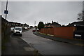
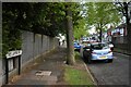
Beechdale Avenue off Dunedin Road - Kingstanding, North Birmingham
This is Beechdale Avenue, a cul de sac leading south-west off Dunedin Road. This road (Dunedin) connects the B4149 King's Road with the B4138 Kingstanding Road. Time photo taken 2.18 pm GMT (Greenwich Mean Time).
Image: © Martin Richard Phelan
Taken: 7 Jan 2020
0.17 miles
4

Road sign styles 6 Southgate Road - Kingstanding, North Birmingham
Another road sign style in this series of street name signs from Birmingham. This one in Kingstanding carries the present area code of 44 for this area and also shows the City coat of arms bearing the motto 'Forward'. Time photo taken 2.25 pm GMT (Greenwich Mean Time).
Image: © Martin Richard Phelan
Taken: 7 Jan 2020
0.18 miles
5
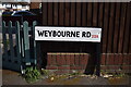
Road sign styles 8 Weybourne Road - Kingstanding, North Birmingham
These two photos were taken at the north-east end of Weybourne Road at its junction with Dunedin Road. Showing the current designation of this area as Birmingham 44, this sign stands on the right hand side of Weybourne Road facing south-west. Time photo taken 2.18 pm BST (British Summer Time). Image]
Image: © Martin Richard Phelan
Taken: 21 Apr 2020
0.19 miles
6
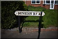
Road sign styles 3 Dunedin Road - Kingstanding, North Birmingham
This road sign on Dunedin Road is one of the earlier styles. It stands facing the north-eastern end of Southgate Road in Kingstanding. Time photo taken 2.20 pm BST (British Summer Time).
Image] Image]
Image: © Martin Richard Phelan
Taken: 21 Apr 2020
0.19 miles
7
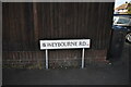
Road sign styles 7 Weybourne Road - Kingstanding, North Birmingham
These two photos were taken at the north-east end of Weybourne Road at its junction with Dunedin Road. Harking back to the time when this area was designated Birmingham 22, this sign stands on the left of Weybourne Road facing south-west. Time photo taken 2.17 pm BST (British Summer Time). Image]
Image: © Martin Richard Phelan
Taken: 21 Apr 2020
0.19 miles
8
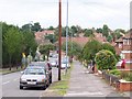
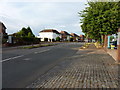
Atlantic Road - Kingstanding, North Birmingham
A view southwards on Atlantic Road, Kingstanding from its junction with Old Oscott Hill. Here was the childhood home of Steve Winwood, singer, vocalist and guitarist. A member of the Spencer Davis Group, he was later with Traffic, Blind Faith and Ginger Baker’s Air Force and has sold over 50 million records. Time photo taken 6.15 pm BST (British Summer Time)
Image: © Martin Richard Phelan
Taken: 15 May 2021
0.21 miles
9
Houses on Shady Lane at Queslett
Taken from the roadside outside a small industrial estate.
Image: © Richard Law
Taken: 9 Aug 2018
0.22 miles