IMAGES TAKEN NEAR TO
Aldridge Road, BIRMINGHAM, B42 2SP
Introduction
This page details the photographs taken nearby to Aldridge Road, B42 2SP by members of the Geograph project.
The Geograph project started in 2005 with the aim of publishing, organising and preserving representative images for every square kilometre of Great Britain, Ireland and the Isle of Man.

There are currently over 7.5m images from over14,400 individuals and you can help contribute to the project by visiting https://www.geograph.org.uk
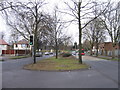
Image Map
Images are licensed for reuse under creativecommons.org/licenses/by-sa/2.0
Notes
- Clicking on the map will re-center to the selected point.
- The higher the marker number, the further away the image location is from the centre of the postcode.
Image Listing (67 Images Found)
Images are licensed for reuse under creativecommons.org/licenses/by-sa/2.0
Image
Details
Distance
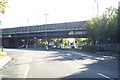
2
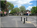
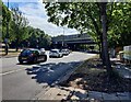
Aldridge Road south - Perry Barr, Birmingham
A view southwards along the A453 Aldridge Road taken from under the M6 Motorway flyover. This, the A453, is one of the main routes into Birmingham City Centre along with the A34 Walsall Road from the North Birmingham area. At the major roundabout in Perry Barr the A34 crosses the A4040. To the west of the A34 this is Wellington Road and to the east is Aston Lane. On the south side of the roundabout the A34 becomes the dual carriageway Birchfield Road. Time photo taken 3.16 pm GMT (Greenwich Mean Time).
Image: © Martin Richard Phelan
Taken: 1 Jan 2020
0.02 miles
3
North on Aldridge Road - Perry Barr, Birmingham
A view north along the A453 Aldridge Road at Perry Barr, Birmingham taken from the Church Road junction with Aldridge Road. Ahead the M6 motorway crosses over and beyond here the Aldridge Road becomes College Road on its way to Kingstanding and Sutton Coldfield. Time photo taken 2.06 pm BST (British Summer Time).
Image: © Martin Richard Phelan
Taken: 30 May 2015
0.02 miles
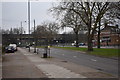
4
Aldridge Road, Perry Barr
Looking towards the junction with Church Road on the left and with the M6 Motorway running along the embankment on the horizon.
Image: © Roy Hughes
Taken: 21 Jan 2009
0.05 miles
5
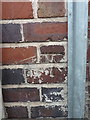
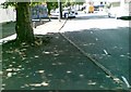
OS benchmark - Perry Barr, 281 Aldridge Road
An OS cutmark on the wall of 281 Aldridge Road, which was originally levelled, probably in 1962, at 96.713m above Ordnance Datum Newlyn.
Image: © Richard Law
Taken: 8 Mar 2018
0.06 miles
6
Aldridge Road in Perry, Birmingham
Looking towards the M6 motorway bridge.
Image: © Mat Fascione
Taken: 31 Jul 2022
0.07 miles
7
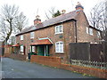
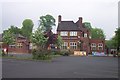
Listed cottages on Church Road
Given a Grade II listing https://www.britishlistedbuildings.co.uk/101220881-215-17-and-15-church-road-perry-barr-ward#.Wqmg-NSLTGg in 1975, these three cottages date from the early 19th century, and are numbered 17, 15 and 2/15 Church Road.
Image: © Richard Law
Taken: 8 Mar 2018
0.08 miles
8
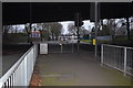
No Access
The M6 passes over the A453 at the Aldridge Road/College Road junction. Containerbase is just to the left; Perry Park just to the right. It'd be handy for me if you could get onto the M6 here!
Image: © Adrian Bailey
Taken: 2 Oct 2004
0.09 miles
9
On College Road - Perry Barr, Birmingham
This view is looking south-west on College Road, North Birmingham. Ahead is the Aldridge Road joining from the right. Having passed under the M6 (M - Motorway) the A453 College Road becomes the Aldridge Road. On the right of the photo is the Boars Head World Buffet Restaurant & (an ampersand meaning and) Cocktail Bar. Time photo taken 3.04 pm GMT (Greenwich Mean Time).
Image: © Martin Richard Phelan
Taken: 1 Jan 2020
0.09 miles