IMAGES TAKEN NEAR TO
Fowlmere Road, BIRMINGHAM, B42 2EA
Introduction
This page details the photographs taken nearby to Fowlmere Road, B42 2EA by members of the Geograph project.
The Geograph project started in 2005 with the aim of publishing, organising and preserving representative images for every square kilometre of Great Britain, Ireland and the Isle of Man.

There are currently over 7.5m images from over14,400 individuals and you can help contribute to the project by visiting https://www.geograph.org.uk
Image Map
Images are licensed for reuse under creativecommons.org/licenses/by-sa/2.0
Notes
- Clicking on the map will re-center to the selected point.
- The higher the marker number, the further away the image location is from the centre of the postcode.
Image Listing (12 Images Found)
Images are licensed for reuse under creativecommons.org/licenses/by-sa/2.0
Image
Details
Distance
1
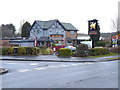
The New Bell Inn
Located at the junction of Cramlington Road with Booths Farm Road; the sign shows a bellmaker astride his new bell.
Image: © Richard Law
Taken: 8 Mar 2018
0.15 miles
2
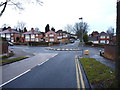
Junction of Booths Farm Road with Foden Road
A small roundabout (which probably helps with traffic calming) at the junction of Booths Farm Road with Foden Road.
Image: © Richard Law
Taken: 8 Mar 2018
0.19 miles
3
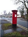
GR postbox on Perry Wood Road
Cast iron post box (numbered B42 399) dating from the reign of King George V, which was between 1910 and 1936. The latter part of this period fits quite neatly with the building of the houses in this area of Birmingham.
Image: © Richard Law
Taken: 8 Mar 2018
0.21 miles
7

Along Perry Wood Road
Mid-1930s (or thereabouts) housing on the extensive Perry Beeches estate.
Image: © Richard Law
Taken: 8 Mar 2018
0.23 miles
8

OS benchmark - Perry Beeches, Perry Wood Road
An OS cutmark on a wall buttress at the side of Perry Wood Road; originally levelled, probably in 1962, at 140.876m above Ordnance Datum Newlyn.
Image: © Richard Law
Taken: 8 Mar 2018
0.23 miles