IMAGES TAKEN NEAR TO
Baltimore Road, BIRMINGHAM, B42 1QL
Introduction
This page details the photographs taken nearby to Baltimore Road, B42 1QL by members of the Geograph project.
The Geograph project started in 2005 with the aim of publishing, organising and preserving representative images for every square kilometre of Great Britain, Ireland and the Isle of Man.

There are currently over 7.5m images from over14,400 individuals and you can help contribute to the project by visiting https://www.geograph.org.uk
Image Map
Images are licensed for reuse under creativecommons.org/licenses/by-sa/2.0
Notes
- Clicking on the map will re-center to the selected point.
- The higher the marker number, the further away the image location is from the centre of the postcode.
Image Listing (9 Images Found)
Images are licensed for reuse under creativecommons.org/licenses/by-sa/2.0
Image
Details
Distance
1
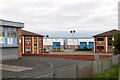
Great Barr Business Park
From the railway.
Image: © Andrew Abbott
Taken: 25 May 2019
0.05 miles
2
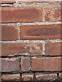
OS benchmark - Perry Barr, 122 Lavendon Road
An OS cutmark on the gatepost/wall right outside 122 Lavendon Road; originally levelled, probably in 1962, at 110.652m above Ordnance Datum Newlyn.
Image: © Richard Law
Taken: 8 Mar 2018
0.15 miles
3
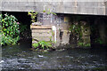
Under the River Tame railway bridge, Perry Barr
The bridge carries the Grand Junction line over the River Tame between Perry Barr and Hamstead stations. After several rainy weeks the river flow is strong but as the level marker shows, there is no risk of flooding.
Image: © Stephen McKay
Taken: 25 Jul 2023
0.16 miles
4
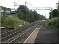
Grand Junction Railway east of Hamstead station
The original Crewe-Birmingham railway line avoided Wolverhampton and approached Birmingham along the more easily accessed land of the Tame Valley. The line has renewed importance in the 21st century due to saturation of the later direct route via Tipton and Smethwick.
Image: © Peter Whatley
Taken: 29 Sep 2008
0.18 miles
5

Perry Hall Methodist Church
The church lies at the junction of Lavendon Road with Rocky Lane.
Image: © Richard Law
Taken: 8 Mar 2018
0.19 miles
6

Tame River Walk
The well-surfaced path and cycleway connects Hamstead Hill with Perry Hall Park alongside the River Tame.
Image: © Stephen McKay
Taken: 25 Jul 2023
0.19 miles
7

River Tame, Hamstead
The river winds past the open area to the right on its way down to Perry Barr.
Image: © Stephen McKay
Taken: 25 Jul 2023
0.19 miles
8
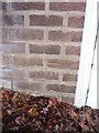
OS benchmark - Perry Barr, 211 Cherry Orchard Road
An OS cutmark on the garage wall at 211 Cherry Orchard Road; originally levelled, probably in 1962, at 107.095m above Ordnance Datum Newlyn.
Image: © Richard Law
Taken: 8 Mar 2018
0.24 miles
9
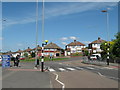
Traffic Island, Rocky Lane - Tower Hill Joining From Right
Image: © Roy Hughes
Taken: 12 May 2009
0.25 miles