IMAGES TAKEN NEAR TO
Sandringham Road, BIRMINGHAM, B42 1PU
Introduction
This page details the photographs taken nearby to Sandringham Road, B42 1PU by members of the Geograph project.
The Geograph project started in 2005 with the aim of publishing, organising and preserving representative images for every square kilometre of Great Britain, Ireland and the Isle of Man.

There are currently over 7.5m images from over14,400 individuals and you can help contribute to the project by visiting https://www.geograph.org.uk
Image Map
Images are licensed for reuse under creativecommons.org/licenses/by-sa/2.0
Notes
- Clicking on the map will re-center to the selected point.
- The higher the marker number, the further away the image location is from the centre of the postcode.
Image Listing (45 Images Found)
Images are licensed for reuse under creativecommons.org/licenses/by-sa/2.0
Image
Details
Distance
2
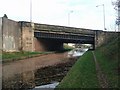
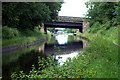
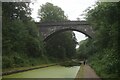
Tame Valley Canal - A34 Walsall Road Bridge
The bridge was re-built in 1932. The concrete on the left appears a more recent addition.
Image: © John M
Taken: 22 Nov 2008
0.08 miles
5
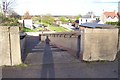
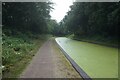
Perry Barr Locks
The top locks viewed from the Walsall Road (A34).
Image: © Adrian Bailey
Taken: 18 Apr 2005
0.10 miles
9
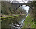
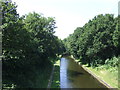
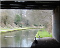
Freeth Bridge crossing the Tame Valley Canal
Image: © Mat Fascione
Taken: 1 Apr 2018
0.12 miles