IMAGES TAKEN NEAR TO
Glenroyde, BIRMINGHAM, B38 9UT
Introduction
This page details the photographs taken nearby to Glenroyde, B38 9UT by members of the Geograph project.
The Geograph project started in 2005 with the aim of publishing, organising and preserving representative images for every square kilometre of Great Britain, Ireland and the Isle of Man.

There are currently over 7.5m images from over14,400 individuals and you can help contribute to the project by visiting https://www.geograph.org.uk
Image Map
Images are licensed for reuse under creativecommons.org/licenses/by-sa/2.0
Notes
- Clicking on the map will re-center to the selected point.
- The higher the marker number, the further away the image location is from the centre of the postcode.
Image Listing (21 Images Found)
Images are licensed for reuse under creativecommons.org/licenses/by-sa/2.0
Image
Details
Distance
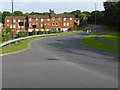
1

Houses in Hawkesley
These houses at Hawkesley around roughly directly above the Wast Hill Tunnel on the Worcester and Birmingham Canal.
Image: © Philip Halling
Taken: 20 Apr 2013
0.07 miles
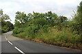
2
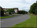
Longdales Road, Hawkesley - Wast Hill tunnel goes through under here
The Worcester & Birmingham Canal goes through under the road in the middle of this view.
Image: © Chris Allen
Taken: 29 Aug 2015
0.08 miles

4
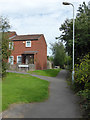
Lichen Gardens and Low Thatch, Hawkesley
There is a tiny stream off to the right
Image: © Chris Allen
Taken: 29 Aug 2015
0.14 miles
5
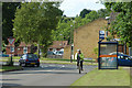
Bus stop & cyclist near Longsdale Rd
Bus stop (clockwise) Bracken Way connecting Longsdale Rd and Redhill Lane, King's Norton between The Man on the Moon pub on Redditch Rd and The Peacock pub on Icknield St an ancient pre-Roman way.
Image: © Row17
Taken: 16 Jun 2009
0.16 miles

7

The Shannon public house
Located on Old Portway in Hawkesley, the pub's only recently changed its name from The Tunnel.
Image: © Richard Law
Taken: 26 Feb 2020
0.18 miles
8

Streetworks, Bracken Way, West Heath
Relating to a new residential estate right up to Birmingham's southern boundary.
Image: © Robin Stott
Taken: 30 Nov 2013
0.19 miles
10
Bracken Way, Hawkesley
A Birmingham suburb that I had to traverse while walking over Wast Hills from one end of the eponymous Worcester & Birmingham Canal tunnel to the other. The only sensible and legal way through the tunnel is by powered boat (unpowered craft are prohibited).
Image: © Chris Allen
Taken: 29 Aug 2015
0.19 miles