IMAGES TAKEN NEAR TO
Primrose Hill, BIRMINGHAM, B38 9HA
Introduction
This page details the photographs taken nearby to Primrose Hill, B38 9HA by members of the Geograph project.
The Geograph project started in 2005 with the aim of publishing, organising and preserving representative images for every square kilometre of Great Britain, Ireland and the Isle of Man.

There are currently over 7.5m images from over14,400 individuals and you can help contribute to the project by visiting https://www.geograph.org.uk
Image Map
Images are licensed for reuse under creativecommons.org/licenses/by-sa/2.0
Notes
- Clicking on the map will re-center to the selected point.
- The higher the marker number, the further away the image location is from the centre of the postcode.
Image Listing (16 Images Found)
Images are licensed for reuse under creativecommons.org/licenses/by-sa/2.0
Image
Details
Distance
1
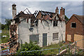
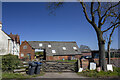
Remains of Lilycroft Farmhouse
Suspected arson gutted the farmhouse, which is Grade II listed and dates from the late 17th or early 18th century, last year. See also Image, Image and Image
Image: © TCExplorer
Taken: 22 Jun 2023
0.00 miles
2
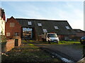
Barn at Lilycroft Farm
The large barn here is probably not the main item of interest in this photo; rather more important is the barn seen at gable-end, which is timber framed beneath the 18th century brick cladding, and which dates from the late 17th century. Along with the adjacent farmhouse Image it was Grade II listed https://britishlistedbuildings.co.uk/101219992-lilycroft-farmhouse-attached-coach-housestabling-and-barn-kings-norton-ward#.X49Z3NBKjIU & https://historicengland.org.uk/listing/the-list/list-entry/1219992 in 1982.
Image: © Richard Law
Taken: 29 Jan 2020
0.01 miles
3
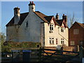
Lilycroft Farmhouse, Kings Norton
This farmhouse, which dates from the late 17th or early 18th century, is likely to be timber framed underneath the roughcast & rendered exterior. It, along with the barn to the right Image, was Grade II listed https://britishlistedbuildings.co.uk/101219992-lilycroft-farmhouse-attached-coach-housestabling-and-barn-kings-norton-ward#.X49Z3NBKjIU & https://historicengland.org.uk/listing/the-list/list-entry/1219992 in 1982.
Image: © Richard Law
Taken: 29 Jan 2020
0.01 miles
4
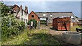
Remains of Lilycroft Farmhouse and barn
Suspected arson gutted the farmhouse, which is Grade II listed and dates from the late 17th or early 18th century, last year. See also Image and Image
Image: © TCExplorer
Taken: 22 Jun 2023
0.01 miles
6
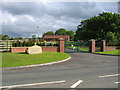
King's Norton Cemetery
The new entry to the Cemetery in Longdales Road.
Image: © David Stowell
Taken: 27 May 2006
0.06 miles
9
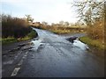
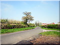
Junction on Icknield Street
Road junction of Icknield Street or Ryknild Street with Primrose Hill, near King's Norton.
Image: © Philip Halling
Taken: 18 Dec 2017
0.10 miles
10
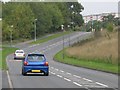
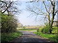
Longdales Road, Hawkesley
Busy road running around the boundary of housing estate.
The flats visible in the distance, are at top end of Primrose Hill, close to mini-island and entrance to cemetery.
Image: © Michael Westley
Taken: 12 Oct 2010
0.11 miles