IMAGES TAKEN NEAR TO
Lea End Lane, BIRMINGHAM, B38 9EE
Introduction
This page details the photographs taken nearby to Lea End Lane, B38 9EE by members of the Geograph project.
The Geograph project started in 2005 with the aim of publishing, organising and preserving representative images for every square kilometre of Great Britain, Ireland and the Isle of Man.

There are currently over 7.5m images from over14,400 individuals and you can help contribute to the project by visiting https://www.geograph.org.uk
Image Map
Images are licensed for reuse under creativecommons.org/licenses/by-sa/2.0
Notes
- Clicking on the map will re-center to the selected point.
- The higher the marker number, the further away the image location is from the centre of the postcode.
Image Listing (12 Images Found)
Images are licensed for reuse under creativecommons.org/licenses/by-sa/2.0
Image
Details
Distance
2
Forhill House, Forhill, from Lea End Lane
Forhill* House was a City of Birmingham remand home for boys in the period 1945-1987. The approach at Forhill and elsewhere was experimental and observational: "the idea was that the home would be used more as an opportunity to try to work out why the child’s behaviours had arisen rather than as a place of punishment." A history may be found at http://www.search.connectinghistories.org.uk/engine/resource/default.asp?theme=&originator=%2Fengine%2Ftheme%2Fdefault.asp&records=871&resource=1663 If demolition of buildings has taken place aerial photos show no sign of it: it appears as a secluded residential development. Estate agents refer to the site as Forhill Manor, a development of 42 houses and flats. Forhill House appears now to be called Forhill Court.
*pronounced forrull
Image: © Robin Stott
Taken: 25 Oct 2013
0.09 miles
3
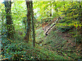
Old pit by Lea End Lane, below Forhill
There are many disused pits in this landscape, perhaps dug for clay for brickmaking as the Arden forest was gradually cleared and colonised.
Image: © Robin Stott
Taken: 25 Oct 2013
0.10 miles
4
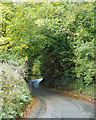
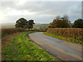
Lea End Lane turns northeast for Forhill
Uphill. Good views.
Image: © Robin Stott
Taken: 25 Oct 2013
0.13 miles
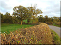
5
A viewpoint on Lea End Lane below Forhill
The lane levels out on this sharp bend, affording a great panorama to the south. This view is towards the village of Hopwood.
Image: © Robin Stott
Taken: 25 Oct 2013
0.13 miles
6
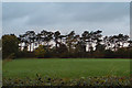
Pines by the private road from Forhill to Forhill Manor
On this ridge these trees are a landmark.
Image: © Robin Stott
Taken: 25 Oct 2013
0.16 miles
7

Oak tree
Close to Forhill picnic area, Looking west.
Image: © John Smith
Taken: 27 Dec 2005
0.23 miles
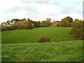
8
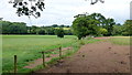
Pastoral North Worcestershire
Rolling green belt land about two miles south of the edge of the Greater Birmingham conurbation.
Image: © Jonathan Billinger
Taken: 30 Jul 2013
0.24 miles

10

The Peacock, Forhill
A busy pub in quiet location at the junction of the road to Lea End with Ryknield Street.
Image: © David Stowell
Taken: 14 Apr 2006
0.24 miles