IMAGES TAKEN NEAR TO
Vardon Way, BIRMINGHAM, B38 8XH
Introduction
This page details the photographs taken nearby to Vardon Way, B38 8XH by members of the Geograph project.
The Geograph project started in 2005 with the aim of publishing, organising and preserving representative images for every square kilometre of Great Britain, Ireland and the Isle of Man.

There are currently over 7.5m images from over14,400 individuals and you can help contribute to the project by visiting https://www.geograph.org.uk
Image Map
Images are licensed for reuse under creativecommons.org/licenses/by-sa/2.0
Notes
- Clicking on the map will re-center to the selected point.
- The higher the marker number, the further away the image location is from the centre of the postcode.
Image Listing (3 Images Found)
Images are licensed for reuse under creativecommons.org/licenses/by-sa/2.0
Image
Details
Distance
1

Chalgrove Avenue, King's Norton
A cul-de-sac off The Fairway.
Image: © Jonathan Billinger
Taken: 28 Jan 2009
0.21 miles
2

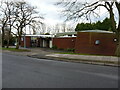
Oddingley Hall
The hall is a modern community centre. In 2017 the hall was advertised as being to let for community use under a 'community asset transfer'.
Image: © Paul Collins
Taken: 9 Jan 2018
0.22 miles
3
The Fairway Centre in Kings Norton
A day centre run by the local council, providing support services for residents in the area.
Image: © Richard Law
Taken: 26 Feb 2020
0.23 miles