IMAGES TAKEN NEAR TO
Grange Hill Road, BIRMINGHAM, B38 8RE
Introduction
This page details the photographs taken nearby to Grange Hill Road, B38 8RE by members of the Geograph project.
The Geograph project started in 2005 with the aim of publishing, organising and preserving representative images for every square kilometre of Great Britain, Ireland and the Isle of Man.

There are currently over 7.5m images from over14,400 individuals and you can help contribute to the project by visiting https://www.geograph.org.uk
Image Map
Images are licensed for reuse under creativecommons.org/licenses/by-sa/2.0
Notes
- Clicking on the map will re-center to the selected point.
- The higher the marker number, the further away the image location is from the centre of the postcode.
Image Listing (9 Images Found)
Images are licensed for reuse under creativecommons.org/licenses/by-sa/2.0
Image
Details
Distance
2

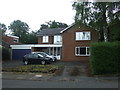
Housing on The Fairway, King's Norton
1960's or 70's houses near the junction with Rednall Road.
Image: © Jonathan Billinger
Taken: 28 Jan 2009
0.15 miles
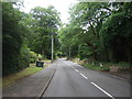
3
Beaks Hill Road, Kings Norton
Looking north.
Image: © JThomas
Taken: 22 Jul 2017
0.17 miles
4
West Heath, Rednal Road With Aversley Road on Right
Image: © Roy Hughes
Taken: 31 May 2011
0.17 miles
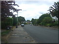
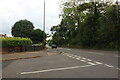
5
Rednal Road, Kings Norton
Looking north east.
Image: © JThomas
Taken: 22 Jul 2017
0.18 miles

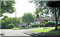
7

Chalgrove Avenue, King's Norton
A cul-de-sac off The Fairway.
Image: © Jonathan Billinger
Taken: 28 Jan 2009
0.20 miles
8
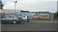
Car Park Mural
Mural on car park wall, Teviot Grove, opposite school
Image: © Michael Westley
Taken: 12 Oct 2010
0.24 miles
9
Redditch Road at the end of Granshaw Close
Image: © David Howard
Taken: 8 Aug 2021
0.24 miles