IMAGES TAKEN NEAR TO
Redditch Road, BIRMINGHAM, B38 8QU
Introduction
This page details the photographs taken nearby to Redditch Road, B38 8QU by members of the Geograph project.
The Geograph project started in 2005 with the aim of publishing, organising and preserving representative images for every square kilometre of Great Britain, Ireland and the Isle of Man.

There are currently over 7.5m images from over14,400 individuals and you can help contribute to the project by visiting https://www.geograph.org.uk
Image Map
Images are licensed for reuse under creativecommons.org/licenses/by-sa/2.0
Notes
- Clicking on the map will re-center to the selected point.
- The higher the marker number, the further away the image location is from the centre of the postcode.
Image Listing (20 Images Found)
Images are licensed for reuse under creativecommons.org/licenses/by-sa/2.0
Image
Details
Distance
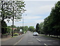
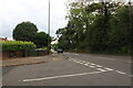
2
Redditch Road at the end of Granshaw Close
Image: © David Howard
Taken: 8 Aug 2021
0.09 miles
3
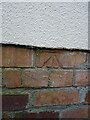
OS benchmark - Kings Norton, 59 Rednal Road
An OS cutmark on the wall of the house, last levelled in 1965 at 167.558m above Ordnance Datum Newlyn.
Image: © Richard Law
Taken: 26 Feb 2020
0.10 miles

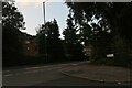
6
Redditch Road at the end of Granshaw Close
Image: © David Howard
Taken: 8 Aug 2021
0.11 miles
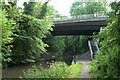
8
King's Norton Bridge No 70
The bridge carries Masshouse Lane across the Worcester and Birmingham Canal.
Image: © Mat Fascione
Taken: 2 May 2021
0.17 miles
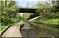
9
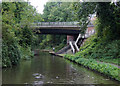
Primrose Hill Bridge near King's Norton, Birmingham
This is Bridge No 70 over the Worcester and Birmingham Canal.
The Worcester and Birmingham Canal was built in stages between 1791 and 1815 to connect the River Severn in Worcester to the Birmingham Canal System using a quicker route than the earlier Staffordshire and Worcestershire Canal. Opposition from other canal companies meant that for twenty years there was no direct connection in Birmingham, the last two and a bit metres of canal there being left uncompleted in 1795. http://wikimapia.org/78582/Worcester-Bar
This lunacy was eventually resolved by an Act of Parliament in 1815 and a stop-lock constructed.
Grain, timber and agricultural produce were carried to the Midlands. Industrial goods and coal were carried down towards Worcester, often for onward transport to Bristol. Later, salt carrying was added as a regular cargo. Pairs of donkeys were often used in preference to horses, maybe because they could easily be put onto the boats which had to be legged (or pulled by tug) through the tunnels.
The canal has five tunnels. The longest at Kings Norton is just under two miles long. Steam tugs were used from the 1870s to haul strings of narrowboats through Wasts Hill, Shortwood and Tardebigge tunnels. The Worcester and Birmingham Canal has locks, 58 of them, climbing 428 feet (130 metres) from the level of the River Severn in Worcester up to Birmingham.
In the twenty-first century the ring now formed by the two canals and the river makes a popular two weeks holiday route, albeit partly a strenuous one, lockwise, but there are plenty of pubs, though some are now merely restaurants with a bar. The Worcester and Birmingham Canal travels through some very pleasant countryside, climbing from the Severn through rolling fields and wooded cuttings and slicing through a hilly ridge south of Birmingham.
http://en.wikipedia.org/wiki/Worcester_and_Birmingham_Canal
Image: © Roger D Kidd
Taken: 25 Aug 2010
0.18 miles
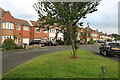
10

Rednal Road Approaching Redhill Road/The Green Junction - Kings Norton
Image: © Roy Hughes
Taken: 31 May 2011
0.18 miles