IMAGES TAKEN NEAR TO
Kings Lodge, BIRMINGHAM, B38 8QQ
Introduction
This page details the photographs taken nearby to Kings Lodge, B38 8QQ by members of the Geograph project.
The Geograph project started in 2005 with the aim of publishing, organising and preserving representative images for every square kilometre of Great Britain, Ireland and the Isle of Man.

There are currently over 7.5m images from over14,400 individuals and you can help contribute to the project by visiting https://www.geograph.org.uk
Image Map
Images are licensed for reuse under creativecommons.org/licenses/by-sa/2.0
Notes
- Clicking on the map will re-center to the selected point.
- The higher the marker number, the further away the image location is from the centre of the postcode.
Image Listing (53 Images Found)
Images are licensed for reuse under creativecommons.org/licenses/by-sa/2.0
Image
Details
Distance
1
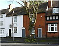
18 & 19 The Green, Kings Norton
Similar in age (circa 1800) to the adjoining Image on their left, but rather more modest in construction. Nos 18 & 19 were also Grade II listed https://britishlistedbuildings.co.uk/101290006-18-and-19-the-green-b38-kings-norton-ward#.YIkbsbVKhPY & https://historicengland.org.uk/listing/the-list/list-entry/1290006 in 1982.
Image: © Richard Law
Taken: 26 Feb 2020
0.09 miles
2
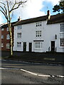
16 & 17 The Green, Kings Norton
These two houses date from the period around 1800, albeit with alterations since then. They were Grade II listed https://britishlistedbuildings.co.uk/101075551-16-and-17-the-green-b38-kings-norton-ward#.YIkag7VKhPY & https://historicengland.org.uk/listing/the-list/list-entry/1075551 in 1982.
Image: © Richard Law
Taken: 26 Feb 2020
0.09 miles
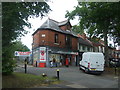
3
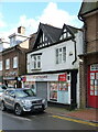
10 The Green, Kings Norton
Until fairly recently a 'Spar' shop, and before that a one-time bakery. Behind the rather bland frontage and modern shop window, the core of the building is possibly as old as late 15th century - a timber-framed house that was Grade II listed https://britishlistedbuildings.co.uk/101211455-hirons-bakery-kings-norton-ward#.YIkYxbVKhPY & https://historicengland.org.uk/listing/the-list/list-entry/1211455 in 1982.
Image: © Richard Law
Taken: 26 Feb 2020
0.10 miles
4
King's Norton Police Station
Beside Wharf Lane, opposite the Navigation Inn.
Image: © David Stowell
Taken: 26 May 2006
0.12 miles
5
The Navigation, King's Norton
This public house is in Wharf Lane which not surprisingly leads to the Worcester & Birmingham Canal. Up until the 1930s a cattle market was regularly held in what is now the pub car park. In those days this was a rather more rural area than today!
Image: © David Stowell
Taken: 26 May 2006
0.12 miles

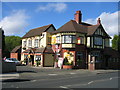
8
The Green Post Office, King's Norton
Showing position of Postbox No. B38 225.
See Image] for postbox.
Image: © JThomas
Taken: 22 Jul 2017
0.12 miles
9
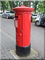
Elizabeth II postbox, The Green Post Office, King's Norton
Postbox No. B38 225.
See Image] for context.
Image: © JThomas
Taken: 22 Jul 2017
0.12 miles
