IMAGES TAKEN NEAR TO
Willoughby Gardens, BIRMINGHAM, B38 8NP
Introduction
This page details the photographs taken nearby to Willoughby Gardens, B38 8NP by members of the Geograph project.
The Geograph project started in 2005 with the aim of publishing, organising and preserving representative images for every square kilometre of Great Britain, Ireland and the Isle of Man.

There are currently over 7.5m images from over14,400 individuals and you can help contribute to the project by visiting https://www.geograph.org.uk
Image Map (Loading...)


Getting Data...Please wait
Leaflet Map data © OpenStreetMap
Images are licensed for reuse under creativecommons.org/licenses/by-sa/2.0
Notes
- Clicking on the map will re-center to the selected point.
- The higher the marker number, the further away the image location is from the centre of the postcode.
Image Listing (8 Images Found)
Images are licensed for reuse under creativecommons.org/licenses/by-sa/2.0
Image
Details
Distance
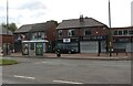
3
Welcome to Hawkesley
Welcome sign on corner of Longdales Road and Shannon Road
Image: © Michael Westley
Taken: 12 Oct 2010
0.17 miles
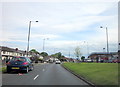
4
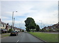
A441 Redditch Road Approaching Kings Norton Boundary
Image: © Roy Hughes
Taken: 31 May 2016
0.19 miles
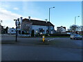
5
A441 Redditch Road and Redhill Road Island
Image: © Roy Hughes
Taken: 31 May 2016
0.20 miles
6
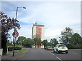
Hobbis House, West Heath
The 10-storey block of flats (I'm not counting the ground floor here) lies on the corner of Redhill Road and Redditch Road.
Image: © Richard Law
Taken: 26 Feb 2020
0.20 miles
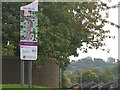
7
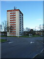
Hobbis House
Dominates the southern approach to the Greater Birmingham conurbation from the A441 Redditch Road.
Image: © Jonathan Billinger
Taken: 10 Nov 2008
0.21 miles