IMAGES TAKEN NEAR TO
Lakehouse Grove, BIRMINGHAM, B38 8AW
Introduction
This page details the photographs taken nearby to Lakehouse Grove, B38 8AW by members of the Geograph project.
The Geograph project started in 2005 with the aim of publishing, organising and preserving representative images for every square kilometre of Great Britain, Ireland and the Isle of Man.

There are currently over 7.5m images from over14,400 individuals and you can help contribute to the project by visiting https://www.geograph.org.uk
Image Map
Images are licensed for reuse under creativecommons.org/licenses/by-sa/2.0
Notes
- Clicking on the map will re-center to the selected point.
- The higher the marker number, the further away the image location is from the centre of the postcode.
Image Listing (20 Images Found)
Images are licensed for reuse under creativecommons.org/licenses/by-sa/2.0
Image
Details
Distance
1

The Rea Valley Cycle Route No. 5 near site of Wychall Reservoir
Image: © Roy Hughes
Taken: 8 Oct 2021
0.05 miles
2

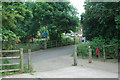
The Fairway Centre in Kings Norton
A day centre run by the local council, providing support services for residents in the area.
Image: © Richard Law
Taken: 26 Feb 2020
0.08 miles
3

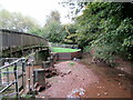
Wychall Reservoir
Wychall Reservoir was originally a canal compensation reservoir. It was built in the early 19th century by the Worcester Canal Company, after mill owners claimed that water was being taken from the River Rea to fill the canal, reducing the working effectiveness of their mills.
Now defunct as a reservoir it has been adopted by Birmingham City Council as a nature reserve. A low level of water is maintained with the drained area now a combination of woodland and reedbed.
Image: © Shantavira
Taken: 25 Feb 2014
0.10 miles
4

Patch of green by the Wychall Road
Looking east on a rainy November morning.
Image: © Jonathan Billinger
Taken: 10 Nov 2008
0.12 miles
5
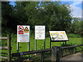
River Rea Walkway signs
The walkway has been created to provide a peaceful path away from traffic along the River Rea valley through the southern suburbs of Birmingham. These signs by Popes Lane provide more information and the usual H&S warnings. See http://www.riverreatrail.org.uk/
Image: © David Stowell
Taken: 26 May 2006
0.12 miles
6
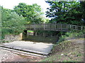
River Rea flood weir
This overflow weir allows the river to flood into a holding area in order to balance the flow at times of high water after heavy rains. The bridge carries the Image
Image: © David Stowell
Taken: 26 May 2006
0.12 miles
7
Rea Valley Route (from Longbridge to the City Centre)
Image: © Row17
Taken: 5 Jun 2009
0.12 miles
9

Parade of shops in Wychall Road, King's Norton
Various businesses from general to specialist.
A rainy November morning.
Image: © Jonathan Billinger
Taken: 10 Nov 2008
0.13 miles
10

The Rea Valley Cycle Route No. 5 near Wychall Lane, Kings Norton
Image: © Roy Hughes
Taken: 8 Oct 2021
0.13 miles