IMAGES TAKEN NEAR TO
Hiker Grove, BIRMINGHAM, B37 7UY
Introduction
This page details the photographs taken nearby to Hiker Grove, B37 7UY by members of the Geograph project.
The Geograph project started in 2005 with the aim of publishing, organising and preserving representative images for every square kilometre of Great Britain, Ireland and the Isle of Man.

There are currently over 7.5m images from over14,400 individuals and you can help contribute to the project by visiting https://www.geograph.org.uk
Image Map
Images are licensed for reuse under creativecommons.org/licenses/by-sa/2.0
Notes
- Clicking on the map will re-center to the selected point.
- The higher the marker number, the further away the image location is from the centre of the postcode.
Image Listing (28 Images Found)
Images are licensed for reuse under creativecommons.org/licenses/by-sa/2.0
Image
Details
Distance
2
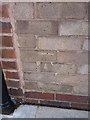
OS benchmark - no 1 Ludlow Close
An OS cutmark in the brickwork of the side wall (adjacent to the back door) of no 1 Ludlow Close, Chelmsley Wood. Originally levelled at 101.681m above Ordnance Datum Newlyn.
Image: © Richard Law
Taken: 4 Feb 2014
0.08 miles
3
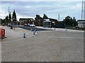
My Coffee Station, Chelmund's Cross, Chelmsley Wood, east Birmingham
Another 3D coffee cup sign is just one of the incongruous components of this upgraded local centre by the A452, along with The Bishop Wilson Primary School and adjoining church, MOT test centre, the wholesale butcher, a building site, Co-operative Food and Funeral Care with defibrillator, car park and more; Image
Image: © Robin Stott
Taken: 10 Aug 2017
0.09 miles
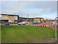
4
Windy Arbor Primary School, Chelmsley Wood, east Birmingham
October 2017 – something is planned: there's Héras fencing in front of the buildings, left. By mid-March 2018 this had become a construction site.
Image: © Robin Stott
Taken: 6 Oct 2017
0.09 miles
5
Bishop Wilson C of E Primary school
A new school for 3 to 11 year old children, maybe not quite finished yet by the look of some of the work going on, on the north side of Chelmsley Wood at Chelmund's Cross. It opened in September 2013, and is the result of significant investment by the Solihull Council and the Birmingham Diocese.
Image: © Richard Law
Taken: 9 Dec 2013
0.10 miles
6
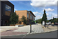
New shops and services, Chelmund's Cross, Chelmsley Wood, east Birmingham
To travellers on the busy A452 Chester Road, right, this is the public face of regeneration in North Solihull http://www.northsolihullarchive.co.uk (caution: the latest date I can find on the website is December 2014).
Image: © Robin Stott
Taken: 10 Aug 2017
0.10 miles
7
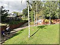
Footpaths near the A452 Chester Road, Chelmsley Wood, east Birmingham
It is believed that there was once a subway here for residents north of the A452 to reach shops and schools but it was blocked up. Currently there is a light-controlled pedestrian crossing which mum and children are heading for.
Image: © Robin Stott
Taken: 6 Oct 2017
0.11 miles
8
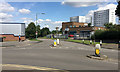
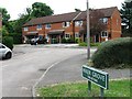
Junction of Dunster Road and Richmond Way, Chelmsley Wood, east Birmingham
Between Laker's premises and the tower blocks the A452 Chester Road drops down to the valley of the River Cole and Bacon's End.
Image: © Robin Stott
Taken: 10 Aug 2017
0.12 miles
9

Shiny new Chelmund's Cross
Instant history
Image: © Alex McGregor
Taken: 16 Jul 2014
0.12 miles