IMAGES TAKEN NEAR TO
Roach Close, BIRMINGHAM, B37 7UH
Introduction
This page details the photographs taken nearby to Roach Close, B37 7UH by members of the Geograph project.
The Geograph project started in 2005 with the aim of publishing, organising and preserving representative images for every square kilometre of Great Britain, Ireland and the Isle of Man.

There are currently over 7.5m images from over14,400 individuals and you can help contribute to the project by visiting https://www.geograph.org.uk
Image Map
Images are licensed for reuse under creativecommons.org/licenses/by-sa/2.0
Notes
- Clicking on the map will re-center to the selected point.
- The higher the marker number, the further away the image location is from the centre of the postcode.
Image Listing (25 Images Found)
Images are licensed for reuse under creativecommons.org/licenses/by-sa/2.0
Image
Details
Distance
2
Funeral Directors - not a church
A disused & presumably deconsecrated church, from which William H Painter, the local funeral director and monumental mason business, is now operating.
Image: © Richard Law
Taken: 13 Jun 2014
0.11 miles
3
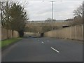
Junction of Dunster Road and Richmond Way, Chelmsley Wood, east Birmingham
Between Laker's premises and the tower blocks the A452 Chester Road drops down to the valley of the River Cole and Bacon's End.
Image: © Robin Stott
Taken: 10 Aug 2017
0.11 miles
5
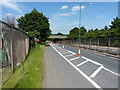
The A452 Chester Road
The road here drops down to allow a bridge to carry Yorkminster Road across the dual carriageway. There are roadworks underway at present, otherwise I'm not sure I'd have been entirely happy cycling it.
Image: © Richard Law
Taken: 13 Jun 2014
0.12 miles
7
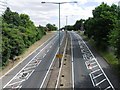
A452 (Chester Road) - Yorkminster Drive overbridge
Image: © Peter Whatley
Taken: 16 Feb 2013
0.13 miles
8
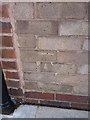
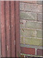
OS benchmark - no 1 Ludlow Close
An OS cutmark in the brickwork of the side wall (adjacent to the back door) of no 1 Ludlow Close, Chelmsley Wood. Originally levelled at 101.681m above Ordnance Datum Newlyn.
Image: © Richard Law
Taken: 4 Feb 2014
0.14 miles
9
OS benchmark - 53 Chelmsley Road
The visible half an OS cutmark on the side wall of no 53 Chelmsley Road; originally levelled at 101.48m above Ordnance Datum Newlyn.
Image: © Richard Law
Taken: 4 Feb 2014
0.15 miles
10
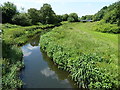
River Cole in Chelmsley Wood
Apart from the fact that you're standing on a dual carriageway bridge, you'd hardly know it was a city-scape.
Image: © Richard Law
Taken: 13 Jun 2014
0.15 miles