IMAGES TAKEN NEAR TO
Yorkminster Drive, BIRMINGHAM, B37 7UE
Introduction
This page details the photographs taken nearby to Yorkminster Drive, B37 7UE by members of the Geograph project.
The Geograph project started in 2005 with the aim of publishing, organising and preserving representative images for every square kilometre of Great Britain, Ireland and the Isle of Man.

There are currently over 7.5m images from over14,400 individuals and you can help contribute to the project by visiting https://www.geograph.org.uk
Image Map
Images are licensed for reuse under creativecommons.org/licenses/by-sa/2.0
Notes
- Clicking on the map will re-center to the selected point.
- The higher the marker number, the further away the image location is from the centre of the postcode.
Image Listing (23 Images Found)
Images are licensed for reuse under creativecommons.org/licenses/by-sa/2.0
Image
Details
Distance
1
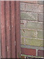
OS benchmark - 53 Chelmsley Road
The visible half an OS cutmark on the side wall of no 53 Chelmsley Road; originally levelled at 101.48m above Ordnance Datum Newlyn.
Image: © Richard Law
Taken: 4 Feb 2014
0.03 miles
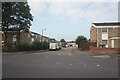
2
Hedgetree Croft off Chelmsley Road, Chelmsley Wood
Image: © Ian S
Taken: 26 Jul 2021
0.07 miles
3
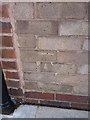
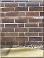
OS benchmark - no 1 Ludlow Close
An OS cutmark in the brickwork of the side wall (adjacent to the back door) of no 1 Ludlow Close, Chelmsley Wood. Originally levelled at 101.681m above Ordnance Datum Newlyn.
Image: © Richard Law
Taken: 4 Feb 2014
0.14 miles
4
Frensham Close off Chelmsley Road, Chelmsley Wood
Image: © Ian S
Taken: 26 Jul 2021
0.15 miles
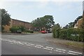
5
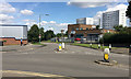
Junction of Dunster Road and Richmond Way, Chelmsley Wood, east Birmingham
Between Laker's premises and the tower blocks the A452 Chester Road drops down to the valley of the River Cole and Bacon's End.
Image: © Robin Stott
Taken: 10 Aug 2017
0.16 miles
6
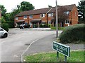
Funeral Directors - not a church
A disused & presumably deconsecrated church, from which William H Painter, the local funeral director and monumental mason business, is now operating.
Image: © Richard Law
Taken: 13 Jun 2014
0.16 miles
8

Chelmsley Wood roundabout
Complete with huge hanging basket structure.
Image: © Steve Fareham
Taken: 17 Sep 2009
0.17 miles
9
OS benchmark - Chelmsley Wood Elec substation
An OS cutmark in the bricks of an electrical substation on Moorend Avenue; originally levelled at 95.879m above Ordnance Datum Newlyn. Well protected behind a steel fence, which in turn was lined by an electrified fence.
Image: © Richard Law
Taken: 27 Feb 2014
0.18 miles
10
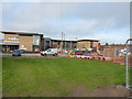
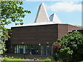
Bishop Wilson C of E Primary school
A new school for 3 to 11 year old children, maybe not quite finished yet by the look of some of the work going on, on the north side of Chelmsley Wood at Chelmund's Cross. It opened in September 2013, and is the result of significant investment by the Solihull Council and the Birmingham Diocese.
Image: © Richard Law
Taken: 9 Dec 2013
0.18 miles