IMAGES TAKEN NEAR TO
Fillingham Close, BIRMINGHAM, B37 7TD
Introduction
This page details the photographs taken nearby to Fillingham Close, B37 7TD by members of the Geograph project.
The Geograph project started in 2005 with the aim of publishing, organising and preserving representative images for every square kilometre of Great Britain, Ireland and the Isle of Man.

There are currently over 7.5m images from over14,400 individuals and you can help contribute to the project by visiting https://www.geograph.org.uk
Image Map
Images are licensed for reuse under creativecommons.org/licenses/by-sa/2.0
Notes
- Clicking on the map will re-center to the selected point.
- The higher the marker number, the further away the image location is from the centre of the postcode.
Image Listing (15 Images Found)
Images are licensed for reuse under creativecommons.org/licenses/by-sa/2.0
Image
Details
Distance
1
Local shops
Craig Croft shops off Dunster Road in Chelmsley Wood.
Image: © Carl Baker
Taken: 10 Sep 2006
0.07 miles
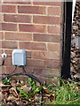
2
OS benchmark - 118 Coleshill Heath Road
An OS cutmark in the brickwork of the side wall of no 118 Coleshill Heath Road; originally levelled at 100.821m above Ordnance Datum Newlyn.
Image: © Richard Law
Taken: 4 Feb 2014
0.08 miles
3

The Greenwood Pub
On Helmswood Drive in Chelmsley Wood.
Image: © Carl Baker
Taken: 10 Sep 2006
0.09 miles
4
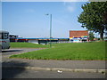
Layby on Coleshill Heath Road, Chelmsley Wood
Buses on route 97 use this layby to lay over between journeys after turning on the roundabout just visible in the distance. Their actual terminus is at the junction of Helmswood Drive and Chelmsley Road, a short way behind the photographer.
Image: © Richard Vince
Taken: 8 Dec 2012
0.09 miles
5

Near the east end of Chelmsley Road, Chelmsley Wood
Photographed from the end of Helmswood Drive, these terraced houses are typical of Chelmsley Wood, a huge housing estate built onto the eastern edge of Birmingham in the 1960s and 1970s but which became part of Solihull borough in 1974. A short way out of frame to the right, Chelmsley Road meets Coleshill Heath Road, and housing gives way to countryside.
Image: © Richard Vince
Taken: 8 Dec 2012
0.10 miles
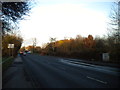
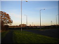
6
Pedestrian crossing on Coleshill Heath Road
Image: © Peter Whatley
Taken: 16 Feb 2013
0.10 miles
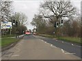
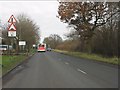
7
A452 roundabout, Coleshill Heath Road
Image: © Peter Whatley
Taken: 16 Feb 2013
0.10 miles
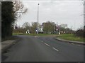
8
Junction of Coleshill Heath Road and Chester Road
Coleshill Heath Road (left) heads north east along the edge of the colossal Chelmsley Wood housing estate while Chester Road (the A452, right) heads south east towards Leamington Spa.
Image: © Richard Vince
Taken: 8 Dec 2012
0.13 miles
9
Coleshill Heath Road nearing Chelmsley Road
Image: © Peter Whatley
Taken: 16 Feb 2013
0.13 miles
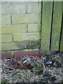
10
OS benchmark - 184 Coleshill Heath Road
An OS cutmark in the brickwork of no 184 Coleshill Heath Road; originally levelled at 99.931m above Ordnance Datum Newlyn.
Image: © Richard Law
Taken: 9 Dec 2013
0.14 miles