IMAGES TAKEN NEAR TO
Starkey Croft, BIRMINGHAM, B37 7SH
Introduction
This page details the photographs taken nearby to Starkey Croft, B37 7SH by members of the Geograph project.
The Geograph project started in 2005 with the aim of publishing, organising and preserving representative images for every square kilometre of Great Britain, Ireland and the Isle of Man.

There are currently over 7.5m images from over14,400 individuals and you can help contribute to the project by visiting https://www.geograph.org.uk
Image Map
Images are licensed for reuse under creativecommons.org/licenses/by-sa/2.0
Notes
- Clicking on the map will re-center to the selected point.
- The higher the marker number, the further away the image location is from the centre of the postcode.
Image Listing (20 Images Found)
Images are licensed for reuse under creativecommons.org/licenses/by-sa/2.0
Image
Details
Distance
1
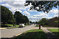
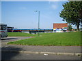
Southeast on Chelmsley Road, Chelmsley Wood, east Birmingham
Before the development of Chelmsley Wood this was Coleshill Heath, farmland. The extensive new suburb or village first appears on an OS map of 1971. The wider area is sometimes referred to as North Solihull, the subject of some regeneration.
Image: © Robin Stott
Taken: 10 Aug 2017
0.05 miles
2
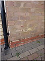
OS benchmark - 129 Chelmsley Road
An OS cutmark on the side wall of no 129 Chelmsley Road; originally levelled at 98.847m above Ordnance Datum Newlyn.
Image: © Richard Law
Taken: 4 Feb 2014
0.06 miles
3

Chelmsley Wood Baptist Church
Much building and renewal work is taking place around this part of town at present, and a distant picture of the church proved more or less impossible due to access restrictions.
Image: © Richard Law
Taken: 9 Dec 2013
0.09 miles
4

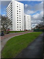
Marlene Croft and Trevelyan House, Chelmsley Wood, east Birmingham
Trevelyan House conceals the identical Richmond House. Pairs of tower blocks among low-rise housing is characteristic of Chelmsley Wood and other parts of North Solihull.
Image: © Robin Stott
Taken: 10 Aug 2017
0.11 miles
5
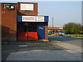
The Forum Gym
At the rear of the shops in Craig Croft.
Image: © Carl Baker
Taken: 11 Sep 2006
0.12 miles
7
Richmond House and Trevelyan House
A pair of (almost) identical late-1960s tower blocks, built by Bryant Construction on the Chelmsley Wood housing estate. Each is 11 storeys high (not including the ground floor) with 40 flats in Richmond, and 45 flats in Trevelyan.
Image: © Richard Law
Taken: 4 Feb 2014
0.13 miles
8
Local shops
Craig Croft shops off Dunster Road in Chelmsley Wood.
Image: © Carl Baker
Taken: 10 Sep 2006
0.15 miles
9
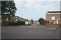
Frensham Close off Chelmsley Road, Chelmsley Wood
Image: © Ian S
Taken: 26 Jul 2021
0.15 miles
10
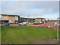
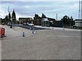
Bishop Wilson C of E Primary school
A new school for 3 to 11 year old children, maybe not quite finished yet by the look of some of the work going on, on the north side of Chelmsley Wood at Chelmund's Cross. It opened in September 2013, and is the result of significant investment by the Solihull Council and the Birmingham Diocese.
Image: © Richard Law
Taken: 9 Dec 2013
0.15 miles