IMAGES TAKEN NEAR TO
Willow Way, BIRMINGHAM, B37 7PW
Introduction
This page details the photographs taken nearby to Willow Way, B37 7PW by members of the Geograph project.
The Geograph project started in 2005 with the aim of publishing, organising and preserving representative images for every square kilometre of Great Britain, Ireland and the Isle of Man.

There are currently over 7.5m images from over14,400 individuals and you can help contribute to the project by visiting https://www.geograph.org.uk
Image Map
Images are licensed for reuse under creativecommons.org/licenses/by-sa/2.0
Notes
- Clicking on the map will re-center to the selected point.
- The higher the marker number, the further away the image location is from the centre of the postcode.
Image Listing (20 Images Found)
Images are licensed for reuse under creativecommons.org/licenses/by-sa/2.0
Image
Details
Distance
1
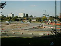
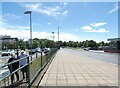
Chelmsley Wood
Picture taken from foot bridge side of shopping centre 090306.
Image: © Carl Baker
Taken: 9 Mar 2006
0.06 miles
2
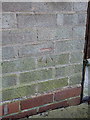
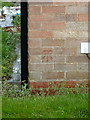
OS benchmark - Chelmsley Wood, 1 Moorend Avenue
An OS cutmark in the bricks on the side wall of no 1 Moorend Avenue; originally levelled at 89.562m above Ordnance Datum Newlyn.
Image: © Richard Law
Taken: 27 Feb 2014
0.06 miles
3
Looking towards Pine Square
Photo taken from foot bridge.
Image: © Carl Baker
Taken: 9 Mar 2006
0.11 miles
4
Pine Square
In the process of the redevelopment of Chelmsley Wood.
Image: © Carl Baker
Taken: 5 Oct 2007
0.13 miles
5
OS benchmark - Chelmsley Wood, 41 Beech Avenue
An OS cutmark in the bricks of a house on Beech Avenue, adjacent to Moorend Avenue; originally levelled at 94.114m above Ordnance Datum Newlyn.
Image: © Richard Law
Taken: 27 Feb 2014
0.17 miles
7
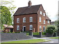
Alcott Hall
A remarkable survivor in the middle of Chelmsley Wood. Alcott Hall is the original 18th century farmhouse of the area, and is certainly shown on the maps of the late 18th century, at which time the adjacent Berwicks Lane was marked as a footpath. The house attracted a Grade II listing in 1976 https://www.britishlistedbuildings.co.uk/101055808-alcott-hall-chelmsley-wood#.WSKJJesrKM8 and now stands rather incongruously amongst extensive modern housing estates. It is now a small business centre.
Image: © Richard Law
Taken: 3 May 2017
0.19 miles
8
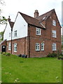
Alcott Hall - rear view
A remarkable survivor in the middle of Chelmsley Wood. Alcott Hall is the original 18th century farmhouse of the area, and is certainly shown on the maps of the late 18th century, at which time the adjacent Berwicks Lane was marked as a footpath. The house attracted a Grade II listing in 1976 https://www.britishlistedbuildings.co.uk/101055808-alcott-hall-chelmsley-wood#.WSKJJesrKM8 and now stands rather incongruously amongst extensive modern housing estates. It is now a small business centre.
Image: © Richard Law
Taken: 3 May 2017
0.19 miles
9
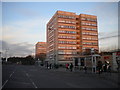
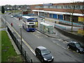
High rise flats in Chelmsley Wood
Chelmsley Wood could perhaps be described as a new town rather than a housing estate; after all, it is sufficiently large to have its own town centre. These tower blocks (Dillington House in the foreground, with Chestnut House behind) are located on the eastern side of Chelmsley Circle, the road that encircled the town centre until its recent redevelopment removed its western side. The remaining section of the road is heavily used by buses serving Chelmsley Wood town centre, hence the row of bus shelters.
Image: © Richard Vince
Taken: 8 Dec 2012
0.19 miles
10
Another pub closes down
The Trusty Servant pub in Chelmsley Wood Shopping Centre.
Image: © Carl Baker
Taken: 11 Sep 2006
0.19 miles