IMAGES TAKEN NEAR TO
Greenlands Road, BIRMINGHAM, B37 7LU
Introduction
This page details the photographs taken nearby to Greenlands Road, B37 7LU by members of the Geograph project.
The Geograph project started in 2005 with the aim of publishing, organising and preserving representative images for every square kilometre of Great Britain, Ireland and the Isle of Man.

There are currently over 7.5m images from over14,400 individuals and you can help contribute to the project by visiting https://www.geograph.org.uk
Image Map
Images are licensed for reuse under creativecommons.org/licenses/by-sa/2.0
Notes
- Clicking on the map will re-center to the selected point.
- The higher the marker number, the further away the image location is from the centre of the postcode.
Image Listing (9 Images Found)
Images are licensed for reuse under creativecommons.org/licenses/by-sa/2.0
Image
Details
Distance
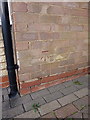
1
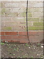
OS benchmark - Chelmsley Wood, 10 Nevada Way
An OS cutmark in the brickwork of no 10 Nevada Way on the huge Chelmsley Wood housing estate; originally levelled at 97.816m above Ordnance Datum Newlyn.
Image: © Richard Law
Taken: 4 Feb 2014
0.04 miles
2

Chelmsley Chippy and Tiwana?s, by Greenlands Road, Chelmsley Wood, east Birmingham
Fast food and a convenience store in the heart of this huge estate.
Image: © Robin Stott
Taken: 10 Aug 2017
0.12 miles
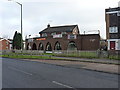
3
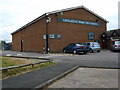
Chemlsley Wood Council Building
Situated on Berwicks Lane,this building contains squash courts and a private members club.
Image: © Carl Baker
Taken: 15 Aug 2006
0.15 miles
4
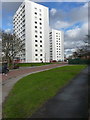
Richmond House and Trevelyan House
A pair of (almost) identical late-1960s tower blocks, built by Bryant Construction on the Chelmsley Wood housing estate. Each is 11 storeys high (not including the ground floor) with 40 flats in Richmond, and 45 flats in Trevelyan.
Image: © Richard Law
Taken: 4 Feb 2014
0.19 miles
5

Marlene Croft and Trevelyan House, Chelmsley Wood, east Birmingham
Trevelyan House conceals the identical Richmond House. Pairs of tower blocks among low-rise housing is characteristic of Chelmsley Wood and other parts of North Solihull.
Image: © Robin Stott
Taken: 10 Aug 2017
0.19 miles
7
OS benchmark - 129 Chelmsley Road
An OS cutmark on the side wall of no 129 Chelmsley Road; originally levelled at 98.847m above Ordnance Datum Newlyn.
Image: © Richard Law
Taken: 4 Feb 2014
0.23 miles
8
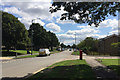
Southeast on Chelmsley Road, Chelmsley Wood, east Birmingham
Before the development of Chelmsley Wood this was Coleshill Heath, farmland. The extensive new suburb or village first appears on an OS map of 1971. The wider area is sometimes referred to as North Solihull, the subject of some regeneration.
Image: © Robin Stott
Taken: 10 Aug 2017
0.23 miles
9
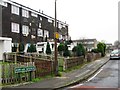
The Greenwood, Helmswood Drive
A very urban pub in Coleshill Heath, a part of Chelmsley Wood.
Image: © Richard Law
Taken: 9 Dec 2013
0.23 miles