IMAGES TAKEN NEAR TO
Coleshill Heath Road, BIRMINGHAM, B37 7JA
Introduction
This page details the photographs taken nearby to Coleshill Heath Road, B37 7JA by members of the Geograph project.
The Geograph project started in 2005 with the aim of publishing, organising and preserving representative images for every square kilometre of Great Britain, Ireland and the Isle of Man.

There are currently over 7.5m images from over14,400 individuals and you can help contribute to the project by visiting https://www.geograph.org.uk
Image Map
Images are licensed for reuse under creativecommons.org/licenses/by-sa/2.0
Notes
- Clicking on the map will re-center to the selected point.
- The higher the marker number, the further away the image location is from the centre of the postcode.
Image Listing (3 Images Found)
Images are licensed for reuse under creativecommons.org/licenses/by-sa/2.0
Image
Details
Distance
1
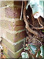
OS benchmark - Coleshill Heath Road
A OS cutmark hiding away behind ivy on the garage wall of a house called Fairford; originally levelled at 99.807m above Ordnance Datum Newlyn.
Image: © Richard Law
Taken: 9 Dec 2013
0.13 miles
2

Thank you for not speeding
An unusual sign on Coleshill Heath Road. The speed shown relates to the vehicle in which I was travelling: the bus ahead was in excess of the 30mph limit in force.
Image: © Peter Whatley
Taken: 16 Feb 2013
0.13 miles
3

OS benchmark - Marston Green, Gorse Farm wall
An OS cutmark in the bricks of a barn facing the Coleshill Road; originally levelled at 98.941m above Ordnance Datum Newlyn.
Image: © Richard Law
Taken: 14 Jan 2014
0.19 miles