IMAGES TAKEN NEAR TO
The Greenway, BIRMINGHAM, B37 7DW
Introduction
This page details the photographs taken nearby to The Greenway, B37 7DW by members of the Geograph project.
The Geograph project started in 2005 with the aim of publishing, organising and preserving representative images for every square kilometre of Great Britain, Ireland and the Isle of Man.

There are currently over 7.5m images from over14,400 individuals and you can help contribute to the project by visiting https://www.geograph.org.uk
Image Map
Images are licensed for reuse under creativecommons.org/licenses/by-sa/2.0
Notes
- Clicking on the map will re-center to the selected point.
- The higher the marker number, the further away the image location is from the centre of the postcode.
Image Listing (17 Images Found)
Images are licensed for reuse under creativecommons.org/licenses/by-sa/2.0
Image
Details
Distance
1
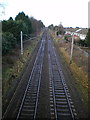
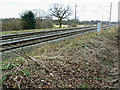
West Coast Main Line to Birmingham
A view from the Elmdon Road bridge, down the WCML in the general direction of Marston Green station, and onwards to Birmingham New Street. When talking about railway lines, the terms 'up' and 'down' are generally used to describe 'London-bound' and 'country-bound' respectively, so this is 'down' the line, as it's away from London.
Image: © Richard Law
Taken: 13 Jan 2014
0.04 miles
2
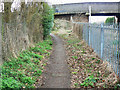
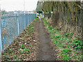
Start of a footpath, Marston Green
The footpath starts just round the corner by the bridge.
Image: © Brian Robert Marshall
Taken: 24 Mar 2010
0.06 miles
3
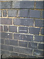
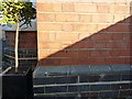
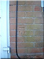
OS benchmark - Marston Green, Elmdon Rd railway bridge
An OS cutmark in the bricks of the Image; originally levelled at 103.56m above Ordnance Datum Newlyn.
Image: © Richard Law
Taken: 13 Jan 2014
0.06 miles
4
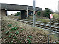
Bridge over railway near Marston Green
The bridge carries Elmdon Road over the railway.
Image: © Brian Robert Marshall
Taken: 24 Mar 2010
0.08 miles
5
OS benchmark - Marston Green, 104 Elmdon Road
An OS cutmark on the wall of 104 Elmdon Road; originally levelled at 101.93m above Ordnance Datum Newlyn.
Image: © Richard Law
Taken: 20 Jan 2016
0.08 miles
6

Wallbox & OS benchmark in Marston Green
Wallbox B37 44D is built into this brick pillar on the NE side of Elmdon Lane, with an OS cutmark in the brickwork below it, which was originally levelled at 102.3m above Ordnance Datum Newlyn.
Image: © Richard Law
Taken: 20 Jan 2016
0.09 miles
7
Footpath to Birmingham International Airport, Marston Green
The footpath runs south-east from here and terminates near the terminal buildings of BHX.
Image: © Brian Robert Marshall
Taken: 24 Mar 2010
0.09 miles
8
Railway from Birmingham International Station near Birmingham International Airport
BHI is up the line. BHX is behind the viewpoint. Sod's law came into play when a train appeared just as I'd put my camera away.
Image: © Brian Robert Marshall
Taken: 24 Mar 2010
0.10 miles
9
Aylesford Drive
In the 1990's all of the houses were of the same construction in Aylesford Drive, Marston Green. The houses were of two bedrooms with some converted to 3 bedrooms for the larger families. The houses were originally sold on a leasehold basis with owners later purchasing the freehold. The house above backed onto some garages of which behind ran a railway. Photograph taken around 1994.
Image: © John Carver
Taken: 1 Jan 1994
0.13 miles
10
OS benchmark - Marston Green no 59 Elmdon Road
An OS cutmark in the brickwork at the front of no 59, Elmdon Road; originally levelled at 96.599m above Ordnance Datum Newlyn.
Image: © Richard Law
Taken: 13 Jan 2014
0.14 miles