IMAGES TAKEN NEAR TO
Station Road, BIRMINGHAM, B37 7AU
Introduction
This page details the photographs taken nearby to Station Road, B37 7AU by members of the Geograph project.
The Geograph project started in 2005 with the aim of publishing, organising and preserving representative images for every square kilometre of Great Britain, Ireland and the Isle of Man.

There are currently over 7.5m images from over14,400 individuals and you can help contribute to the project by visiting https://www.geograph.org.uk
Image Map
Images are licensed for reuse under creativecommons.org/licenses/by-sa/2.0
Notes
- Clicking on the map will re-center to the selected point.
- The higher the marker number, the further away the image location is from the centre of the postcode.
Image Listing (26 Images Found)
Images are licensed for reuse under creativecommons.org/licenses/by-sa/2.0
Image
Details
Distance
2
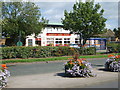
Marston Green Post Office
Viewed from the Marston Green Tavern car park.
Image: © Carl Baker
Taken: 3 Sep 2006
0.05 miles
3
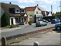
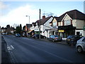
Marston Green Tavern
This public house is in the centre of the village.
Image: © Carl Baker
Taken: 3 Sep 2006
0.06 miles
4
Marston Green Tavern
This public house is located on Station Road.
Image: © Carl Baker
Taken: 3 Sep 2006
0.06 miles
5
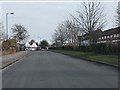
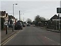
Shops on Station Road, Marston Green
A small arcade of shops and salons on the road leading into Marston Green.
Image: © Richard Law
Taken: 13 Jan 2014
0.08 miles
7

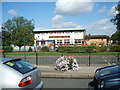
Outside Marston Green Station
Although actually within the borough of Solihull, Marston Green is an outer Birmingham suburb close to the airport. It has a busy station (behind the photographer in this view) that acts as a railhead for Chelmsley Wood.
Image: © Stephen McKay
Taken: 21 Feb 2019
0.14 miles
8
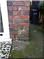
OS benchmark - Marston Green, no 10 Holly Lane
An OS cutmark in the brickwork at the front of no 10 Holly Lane. Originally levelled at 98.2m above Ordnance Datum Newlyn.
Image: © Richard Law
Taken: 16 Jan 2014
0.14 miles
9
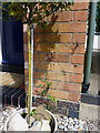
OS benchmark - Marston Green, no 11 Elmdon Lane
An OS cutmark in the frontage of no 11 Elmdon lane; originally levelled at 97.86m above Ordnance Datum Newlyn.
Image: © Richard Law
Taken: 6 May 2014
0.16 miles
10
Elmdon Road junction, Marston Green
The elegant clock is a local feature.
Image: © Peter Whatley
Taken: 16 Feb 2013
0.16 miles