IMAGES TAKEN NEAR TO
Hawksworth Crescent, BIRMINGHAM, B37 6UJ
Introduction
This page details the photographs taken nearby to Hawksworth Crescent, B37 6UJ by members of the Geograph project.
The Geograph project started in 2005 with the aim of publishing, organising and preserving representative images for every square kilometre of Great Britain, Ireland and the Isle of Man.

There are currently over 7.5m images from over14,400 individuals and you can help contribute to the project by visiting https://www.geograph.org.uk
Image Map
Images are licensed for reuse under creativecommons.org/licenses/by-sa/2.0
Notes
- Clicking on the map will re-center to the selected point.
- The higher the marker number, the further away the image location is from the centre of the postcode.
Image Listing (23 Images Found)
Images are licensed for reuse under creativecommons.org/licenses/by-sa/2.0
Image
Details
Distance
1
New estate near the River Cole, Chelmsley Wood, east Birmingham
The visible houses and flats are around Hawksworth Crescent. The line of trees below them marks a steep bank formed to lift the development out of the floodplain, mostly along the historic field boundary: see Image "Liable to flooding" says a pre-war map at the confluence of the Kingshurst Brook and the Cole. The view is from Bacon's End Bridge on the A452 Chester Road.
Image: © Robin Stott
Taken: 6 Oct 2017
0.04 miles
2

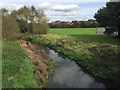
Floodbank near the River Cole, Chelmsley Wood, east Birmingham
Judging by the vegetation along the bank, it was formed mostly along the existing field boundary (a pragmatic guide to the extent of the floodplain). This part of the estate, around Hawksworth Crescent, marks the northern extremity of Chelmsley Wood. See Image
Image: © Robin Stott
Taken: 6 Oct 2017
0.07 miles
3

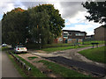
Drake Croft
2000s houses in Chelmsley Wood.
Image: © Burgess Von Thunen
Taken: 21 Feb 2013
0.09 miles

5
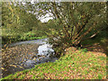
River Cole below Bacon?s End Bridge, east Birmingham
Image: © Robin Stott
Taken: 6 Oct 2017
0.11 miles
6
A452 Chester Road heads for Chelmsley Wood, east Birmingham
The view is from the northwest side of Bacon's End Bridge. This carriageway is supported by an old three-arched sandstone bridge; the other carriageway by a concrete extension first shown on a map for this location of 1973.
Image: © Robin Stott
Taken: 6 Oct 2017
0.12 miles
7
North end of Brook Farm Walk, Chelmsley Wood, east Birmingham
Where it meets Yorkminster Drive.
Image: © Robin Stott
Taken: 6 Oct 2017
0.14 miles
8
Bacon's End Bridge
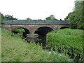
The hamlet and farm at Bacon's End were located roughly at SP179879, a little way to the NNW of this point. The stone bridge seen here, which was incorporated into the modern concrete structure in the 1970s, dates back substantially to the 1760s, and was no doubt a replacement for an earlier bridge over the river. It was given a Grade II listing https://www.britishlistedbuildings.co.uk/101076760-bacons-end-bridge-fordbridge#.WVZtBdQrLGg in 1976.
Image: © Richard Law
Taken: 12 Jun 2017
0.14 miles
9
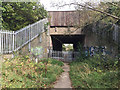
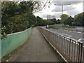
Subway under the M6, Chelmsley Wood, east Birmingham
Green Lane, a public footpath from Partridge Close, leads to Coleshill just over a kilometre away. The subway is reached through a staggered barrier about 1·8m (6 feet) high, making the height about 4m. The walls are a gallery of colourful graffiti; some of the designs are first-rate.
Image: © Robin Stott
Taken: 6 Oct 2017
0.15 miles
10
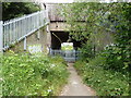
Subway under the M6
Constructed to allow pedestrians (and presumably farm traffic) access along the footpath that runs from Bacon's End to Coleshill. The iron railings across the path make it 'entertaining' to get a mountain bike through the gateway - basically you need to climb up on top of a set of sharp spikes, and lift the bike 8 feet into the air above you. Such fun.
Image: © Richard Law
Taken: 26 Jun 2014
0.15 miles