IMAGES TAKEN NEAR TO
Lyecroft Avenue, BIRMINGHAM, B37 6SY
Introduction
This page details the photographs taken nearby to Lyecroft Avenue, B37 6SY by members of the Geograph project.
The Geograph project started in 2005 with the aim of publishing, organising and preserving representative images for every square kilometre of Great Britain, Ireland and the Isle of Man.

There are currently over 7.5m images from over14,400 individuals and you can help contribute to the project by visiting https://www.geograph.org.uk
Image Map
Images are licensed for reuse under creativecommons.org/licenses/by-sa/2.0
Notes
- Clicking on the map will re-center to the selected point.
- The higher the marker number, the further away the image location is from the centre of the postcode.
Image Listing (20 Images Found)
Images are licensed for reuse under creativecommons.org/licenses/by-sa/2.0
Image
Details
Distance
1
Brook Farm Walk, Chelmsley Wood, east Birmingham
Probably planned in the late 1960s, the estate has a variety of dwelling types and many small greenspaces with trees that are now mature. The place feels like a reasonably spacious leafy suburb.
Image: © Robin Stott
Taken: 6 Oct 2017
0.07 miles
2
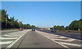
Joining M6 North from M42
Northeast of Chelmsley Wood.
Image: © Robin Stott
Taken: 25 Sep 2010
0.11 miles
3
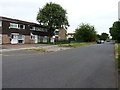
Bluebell Drive, Chelmsley Wood
Part of the extensive 1960s housing development of Chelmsley Wood.
Image: © Richard Law
Taken: 26 Jun 2014
0.11 miles
4
Windy Arbor Primary School, Chelmsley Wood, east Birmingham
October 2017 – something is planned: there's Héras fencing in front of the buildings, left. By mid-March 2018 this had become a construction site.
Image: © Robin Stott
Taken: 6 Oct 2017
0.14 miles
5
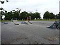
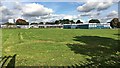
Not a motorway to be seen
A small BMX-jump park on a recreation field at the edge of the housing estate. This is one of only a couple of photos in this square that DON'T feature the M42 or the M6. Or both.
Image: © Richard Law
Taken: 26 Jun 2014
0.14 miles
6
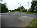
Bluebell Drive joins Yorkminster Drive
Guess what? The motorway lies just off to the right, beyond the line of the pylons.
Image: © Richard Law
Taken: 26 Jun 2014
0.15 miles
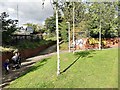
7
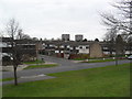
The eastern edge of Chelmsley Wood
The very end of Yorkminster Drive (foreground) is quite rural in character, with a park on the left and agricultural land on the right. However, it is one of the distributor roads serving the eastern end of the colossal Chelmsley Wood housing estate; two of the tower blocks near the middle of the estate can be glimpsed in the distance on the left.
Image: © Richard Vince
Taken: 8 Dec 2012
0.15 miles
8
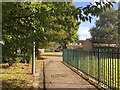
Footpaths near the A452 Chester Road, Chelmsley Wood, east Birmingham
It is believed that there was once a subway here for residents north of the A452 to reach shops and schools but it was blocked up. Currently there is a light-controlled pedestrian crossing which mum and children are heading for.
Image: © Robin Stott
Taken: 6 Oct 2017
0.16 miles
9
Chelmsley Wood
A large 1970s council estate on the edge of Birmingham.
Image: © Burgess Von Thunen
Taken: 21 Feb 2013
0.16 miles
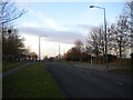
10
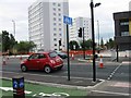
New road crossing and junction, Chester Road
Image: © Alex McGregor
Taken: 16 Jul 2014
0.16 miles