IMAGES TAKEN NEAR TO
Braeside Croft, BIRMINGHAM, B37 6SN
Introduction
This page details the photographs taken nearby to Braeside Croft, B37 6SN by members of the Geograph project.
The Geograph project started in 2005 with the aim of publishing, organising and preserving representative images for every square kilometre of Great Britain, Ireland and the Isle of Man.

There are currently over 7.5m images from over14,400 individuals and you can help contribute to the project by visiting https://www.geograph.org.uk
Image Map
Images are licensed for reuse under creativecommons.org/licenses/by-sa/2.0
Notes
- Clicking on the map will re-center to the selected point.
- The higher the marker number, the further away the image location is from the centre of the postcode.
Image Listing (23 Images Found)
Images are licensed for reuse under creativecommons.org/licenses/by-sa/2.0
Image
Details
Distance
1
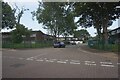
Picton Croft off Dunster Road, Chelmsley Wood
Image: © Ian S
Taken: 26 Jul 2021
0.07 miles
2
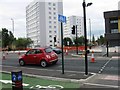
New road crossing and junction, Chester Road
Image: © Alex McGregor
Taken: 16 Jul 2014
0.09 miles
3
Footpaths near the A452 Chester Road, Chelmsley Wood, east Birmingham
It is believed that there was once a subway here for residents north of the A452 to reach shops and schools but it was blocked up. Currently there is a light-controlled pedestrian crossing which mum and children are heading for.
Image: © Robin Stott
Taken: 6 Oct 2017
0.10 miles
4

Shiny new Chelmund's Cross
Instant history
Image: © Alex McGregor
Taken: 16 Jul 2014
0.11 miles
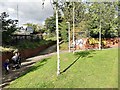
6
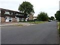
Bluebell Drive, Chelmsley Wood
Part of the extensive 1960s housing development of Chelmsley Wood.
Image: © Richard Law
Taken: 26 Jun 2014
0.12 miles
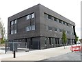
7
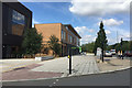
New shops and services, Chelmund's Cross, Chelmsley Wood, east Birmingham
To travellers on the busy A452 Chester Road, right, this is the public face of regeneration in North Solihull http://www.northsolihullarchive.co.uk (caution: the latest date I can find on the website is December 2014).
Image: © Robin Stott
Taken: 10 Aug 2017
0.12 miles
8
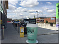
My Coffee Station, Chelmund's Cross, Chelmsley Wood, east Birmingham
Another 3D coffee cup sign is just one of the incongruous components of this upgraded local centre by the A452, along with The Bishop Wilson Primary School and adjoining church, MOT test centre, the wholesale butcher, a building site, Co-operative Food and Funeral Care with defibrillator, car park and more; Image
Image: © Robin Stott
Taken: 10 Aug 2017
0.14 miles
9
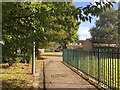
Brook Farm Walk, Chelmsley Wood, east Birmingham
Probably planned in the late 1960s, the estate has a variety of dwelling types and many small greenspaces with trees that are now mature. The place feels like a reasonably spacious leafy suburb.
Image: © Robin Stott
Taken: 6 Oct 2017
0.16 miles
10
Windy Arbor Primary School, Chelmsley Wood, east Birmingham
October 2017 – something is planned: there's Héras fencing in front of the buildings, left. By mid-March 2018 this had become a construction site.
Image: © Robin Stott
Taken: 6 Oct 2017
0.16 miles