IMAGES TAKEN NEAR TO
Brook Farm Walk, BIRMINGHAM, B37 6RX
Introduction
This page details the photographs taken nearby to Brook Farm Walk, B37 6RX by members of the Geograph project.
The Geograph project started in 2005 with the aim of publishing, organising and preserving representative images for every square kilometre of Great Britain, Ireland and the Isle of Man.

There are currently over 7.5m images from over14,400 individuals and you can help contribute to the project by visiting https://www.geograph.org.uk
Image Map
Images are licensed for reuse under creativecommons.org/licenses/by-sa/2.0
Notes
- Clicking on the map will re-center to the selected point.
- The higher the marker number, the further away the image location is from the centre of the postcode.
Image Listing (25 Images Found)
Images are licensed for reuse under creativecommons.org/licenses/by-sa/2.0
Image
Details
Distance
1
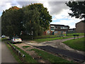
North end of Brook Farm Walk, Chelmsley Wood, east Birmingham
Where it meets Yorkminster Drive.
Image: © Robin Stott
Taken: 6 Oct 2017
0.02 miles
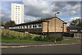
2
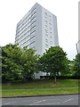
Somerville House
One of the two tower blocks in Image, seen closer up.
Image: © Richard Law
Taken: 26 Jun 2014
0.05 miles
3
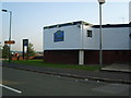
The Bluebell pub
One of the few remaining pubs left on Chelmsley Wood,this one is on Woodlands Way.
Image: © Carl Baker
Taken: 11 Sep 2006
0.07 miles
5
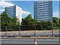
Chelmsley Wood tower blocks
Two large, and apparently identical, tower blocks to the east of the A452 Chester Road.
Image: © Richard Law
Taken: 13 Jun 2014
0.09 miles
6
Cornfield Croft, Chelmsley Wood, east Birmingham
These are flats over garages (FOGs in the jargon), one of several dwelling types on the estate. From this and another image it can be deduced that there are four flats in two pairs, each pair served by one street door and stair. There are thirteen garages. The block of flats is Selwyn House off Waterson Croft. It is one of many in the wider area known as North Solihull, of which Chelmsley Wood is part, first appearing on an OS map of 1971.
Image: © Robin Stott
Taken: 6 Oct 2017
0.12 miles
7
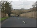
A452 (Chester Road) - Yorkminster Drive overbridge
Image: © Peter Whatley
Taken: 16 Feb 2013
0.12 miles
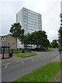
8
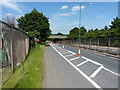
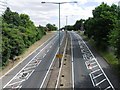
The A452 Chester Road
The road here drops down to allow a bridge to carry Yorkminster Road across the dual carriageway. There are roadworks underway at present, otherwise I'm not sure I'd have been entirely happy cycling it.
Image: © Richard Law
Taken: 13 Jun 2014
0.13 miles
10
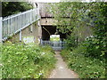
Subway under the M6
Constructed to allow pedestrians (and presumably farm traffic) access along the footpath that runs from Bacon's End to Coleshill. The iron railings across the path make it 'entertaining' to get a mountain bike through the gateway - basically you need to climb up on top of a set of sharp spikes, and lift the bike 8 feet into the air above you. Such fun.
Image: © Richard Law
Taken: 26 Jun 2014
0.16 miles