IMAGES TAKEN NEAR TO
Ipswich Walk, BIRMINGHAM, B37 5RB
Introduction
This page details the photographs taken nearby to Ipswich Walk, B37 5RB by members of the Geograph project.
The Geograph project started in 2005 with the aim of publishing, organising and preserving representative images for every square kilometre of Great Britain, Ireland and the Isle of Man.

There are currently over 7.5m images from over14,400 individuals and you can help contribute to the project by visiting https://www.geograph.org.uk
Image Map
Images are licensed for reuse under creativecommons.org/licenses/by-sa/2.0
Notes
- Clicking on the map will re-center to the selected point.
- The higher the marker number, the further away the image location is from the centre of the postcode.
Image Listing (23 Images Found)
Images are licensed for reuse under creativecommons.org/licenses/by-sa/2.0
Image
Details
Distance
2

The Banbury Club
This club is on Bosworth Drive near to Pine Square in Chelmsley Wood.
Image: © Carl Baker
Taken: 8 Nov 2006
0.13 miles
3

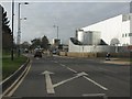
Bosworth Road nearing the Asda superstore
Image: © Peter Whatley
Taken: 16 Feb 2013
0.13 miles
4
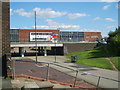
Chelmsley Wood
Chelmsley Wood Shopping Centre in the background.
Image: © Carl Baker
Taken: 7 Sep 2006
0.13 miles
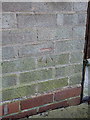
5
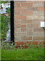
OS benchmark - Chelmsley Wood, 41 Beech Avenue
An OS cutmark in the bricks of a house on Beech Avenue, adjacent to Moorend Avenue; originally levelled at 94.114m above Ordnance Datum Newlyn.
Image: © Richard Law
Taken: 27 Feb 2014
0.15 miles
6
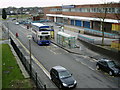
Chelmsley Wood
Picture taken from foot bridge side of shopping centre 090306.
Image: © Carl Baker
Taken: 9 Mar 2006
0.15 miles
7
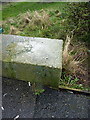
OS benchmark & rivet, Chelmsley Wood
A rather faint OS cutmark and associated rivet on the parapet of the bridge carrying Bosworth Drive over the Kingshurst Brook. Originally levelled at 85.478m above Ordnance Datum Newlyn.
Image: © Richard Law
Taken: 27 Feb 2014
0.15 miles
8
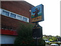
Another pub closes down
The Trusty Servant pub in Chelmsley Wood Shopping Centre.
Image: © Carl Baker
Taken: 11 Sep 2006
0.16 miles
9
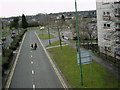
Looking towards Pine Square
Photo taken from foot bridge.
Image: © Carl Baker
Taken: 9 Mar 2006
0.16 miles
10
OS benchmark - Chelmsley Wood, 1 Moorend Avenue
An OS cutmark in the bricks on the side wall of no 1 Moorend Avenue; originally levelled at 89.562m above Ordnance Datum Newlyn.
Image: © Richard Law
Taken: 27 Feb 2014
0.17 miles