IMAGES TAKEN NEAR TO
Collins Way, BIRMINGHAM, B37 5JX
Introduction
This page details the photographs taken nearby to Collins Way, B37 5JX by members of the Geograph project.
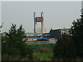
The Geograph project started in 2005 with the aim of publishing, organising and preserving representative images for every square kilometre of Great Britain, Ireland and the Isle of Man.

There are currently over 7.5m images from over14,400 individuals and you can help contribute to the project by visiting https://www.geograph.org.uk
Image Map
Images are licensed for reuse under creativecommons.org/licenses/by-sa/2.0
Notes
- Clicking on the map will re-center to the selected point.
- The higher the marker number, the further away the image location is from the centre of the postcode.
Image Listing (20 Images Found)
Images are licensed for reuse under creativecommons.org/licenses/by-sa/2.0
Image
Details
Distance
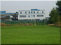
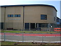
1
Whitesmore School
Viewed from Bell Walk,this comprehensive school will soon be knocked down when the new Grace Academy opens.
Image: © Carl Baker
Taken: 11 Sep 2006
0.05 miles
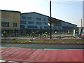
2
Whitesmore School
Viewed from Bell Walk looking across the playing fields.
Image: © Carl Baker
Taken: 11 Sep 2006
0.05 miles
3
Grace Academy
Viewed from Chapelhouse Road.
Image: © Carl Baker
Taken: 15 Aug 2006
0.10 miles
4
Grace Academy
Photo taken from the tennis courts of Whitesmore school which will be knocked down when the Academy opens in September 2006.
Image: © Carl Baker
Taken: 11 Jun 2006
0.14 miles
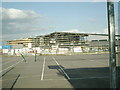
5
Grace Academy
The newly built Grace Academy on Chapelhouse Road.
Image: © Carl Baker
Taken: 11 Sep 2006
0.16 miles
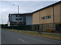
6
Grace Academy
The day before the schools first intake of pupils
Image: © Carl Baker
Taken: 11 Sep 2006
0.16 miles
7
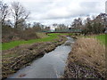
The Hatchford Brook
A small stream draining an area west of Marston Green. Essentially it starts life in Sheldon, is culverted to run under the northern end of the airport runway, and heads off to join the River Cole in Image
Image: © Richard Law
Taken: 16 Jan 2014
0.19 miles
8
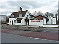
The Ginger Tree restaurant
Formerly this was a pub Image and it must have fairly recently changed use, as the old sign still stands in the carpark as at Jan 2014.
Image: © Richard Law
Taken: 16 Jan 2014
0.20 miles
9
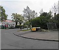
The junction of The Radleys with Bell Lane
Image: © Steve Fareham
Taken: 18 May 2012
0.21 miles
10
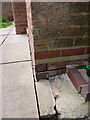
OS benchmark - Tile Cross, 81 Bell Lane
An OS cutmark at the side of no 81 Bell Lane; originally levelled in 1965 at 88.771m above Ordnance Datum Newlyn.
Image: © Richard Law
Taken: 6 May 2014
0.21 miles