IMAGES TAKEN NEAR TO
Triumph Walk, BIRMINGHAM, B36 9NS
Introduction
This page details the photographs taken nearby to Triumph Walk, B36 9NS by members of the Geograph project.
The Geograph project started in 2005 with the aim of publishing, organising and preserving representative images for every square kilometre of Great Britain, Ireland and the Isle of Man.

There are currently over 7.5m images from over14,400 individuals and you can help contribute to the project by visiting https://www.geograph.org.uk
Image Map
Images are licensed for reuse under creativecommons.org/licenses/by-sa/2.0
Notes
- Clicking on the map will re-center to the selected point.
- The higher the marker number, the further away the image location is from the centre of the postcode.
Image Listing (22 Images Found)
Images are licensed for reuse under creativecommons.org/licenses/by-sa/2.0
Image
Details
Distance
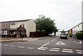
1

Kingfisher Pub
This pub is on Rover Drive in Smithswood.
Image: © Carl Baker
Taken: 1 Nov 2006
0.10 miles
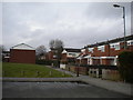
2
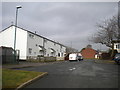
Swift Close, Smith's Wood
The original part of Swift Close, seen from the end of Red Wing Walk. Swift Close has more recently been extended, at 90 degrees to its original alignment, to meet Kingfisher Drive, in order to serve new houses.
Image: © Richard Vince
Taken: 10 Mar 2018
0.10 miles
3
Swift Close off Auckland Drive, Castle Bromwich
Image: © Ian S
Taken: 26 Jul 2021
0.10 miles
4
Wolseley Close, Smith's Wood
A residential cul de sac off Lanchester Way.
Image: © Richard Vince
Taken: 10 Mar 2018
0.11 miles
5

Sunbeam Close, Smith's Wood
Looking towards Rover Drive.
Image: © Richard Vince
Taken: 10 Mar 2018
0.12 miles
6
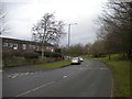
Eastern part of Lanchester Way, Smith's Wood
The A452 Collector Road runs parallel on the other side of the trees (right), with the M6 running parallel on its far side.
Image: © Richard Vince
Taken: 10 Mar 2018
0.12 miles
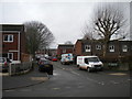
7
Houses off Sunbeam Close, Smith's Wood
Image: © Richard Vince
Taken: 10 Mar 2018
0.13 miles
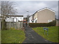
8
Red Wing Walk, Smith's Wood
Looking towards Swift Close.
Image: © Richard Vince
Taken: 10 Mar 2018
0.13 miles
9
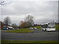
Lanchester Way bus turning circle, Smith's Wood
At the east end of Lanchester Way, where it meets Auckland Drive (foreground). Route 53, a wonderfully meandering route from Erdington, terminates here; igo KX08 UXU, a short wheelbase Alexander Dennis Enviro 200, is laying over between journeys on that service. When Travel West Midlands routes 95 and 99 terminated here, they showed "Chelmsley Wood North" as their destination; the 53, somewhat more appropriately, shows "Smith's Wood".
Image: © Richard Vince
Taken: 10 Mar 2018
0.13 miles
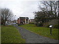
10
Footpath to Auckland Drive, Smith's Wood
Seen from Red Wing Walk. The houses on this path are numbered as part of Auckland Drive (the road at the far end of the path), hence the street sign.
Image: © Richard Vince
Taken: 10 Mar 2018
0.13 miles